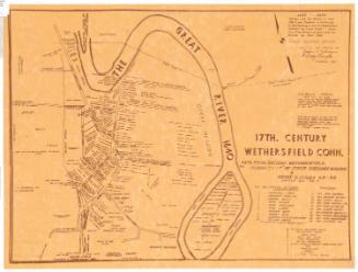
Old Connecticut Path, from Larned's History Windham County
After a work byAfter a work by
Chauncey G. Keeney
(American, about 1810 - 1888)
DraftsmanDrawn by
Unknown
Dateafter 1880
MediumLithography; black printer's ink on wove paper
DimensionsPrimary Dimensions (image height x width): 9 3/8 x 9in. (23.8 x 22.9cm)
Sheet (height x width): 11 3/4 x 11in. (29.8 x 27.9cm)
ClassificationsGraphics
Credit LineConnecticut Museum of Culture and History collection
Object number2004.146.0
DescriptionPocket map of part of the Old Connecticut Path in Ashford, Windham County, Connecticut. The area is divided into nine districts or wards, with local roads and landowners labeled. The Path is marked with a thick black line. Rivers are also depicted. In the top right is an inset map of Westford, a village within the town of Ashford. At the bottom is an explanation of what the Old Connecticut Path was ("Indian trail when John Oldham cruised these wilds in 1633)..
Label TextChauncey D. Keeney lived in Manchester, Connecticut. In 1869, he published an atlas of Tolland and Windham counties that included the map on which the current map is based. Ellen Douglas Larned was born in Thompson, Connecticut on July 13, 1825, and spent almost her entire life in this small town in the northeast part of the state.. She never married, and in 1874, she published the first volume in her two-volume history of Windham County. This map of the Old Connecticut Path did not appear in any editon of Larned's book. It was evidently based on a written description from the book superimposed upon Keeney's map of Ashford. The map has been photographically reduced to such a small scale that it is almost unreadable; the location of the Old Connecticut Path is very imprecise.
NotesCartographic Note: No scaleStatus
Not on view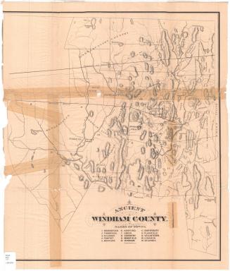

Ithamar P. Berthrong
1908
Towne Crier Marketing, Inc..
1998