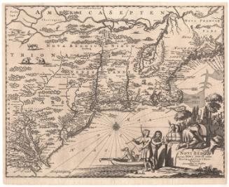
A Plan of the City of Philadelphia and Environs
DraftsmanDrawn by
John Hills
(American, active 1777 - 1817)
PrintmakerEngraved by
William Kneass
(American, 1780 - 1840)
Date1808
MediumEngraving; black printer's ink and watercolor on wove paper, lined with linen, in bound covers
DimensionsPrimary Dimensions (image height x width): 39 3/4 x 39 3/4in. (101 x 101cm)
Sheet (height x width): 40 3/4 x 41 1/4in. (103.5 x 104.8cm)
Mount (height x width): 40 3/4 x 41 1/4in. (103.5 x 104.8cm)
Sheet (height x width): 40 3/4 x 41 1/4in. (103.5 x 104.8cm)
Mount (height x width): 40 3/4 x 41 1/4in. (103.5 x 104.8cm)
ClassificationsHardware
Credit LineConnecticut Museum of Culture and History collection
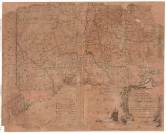
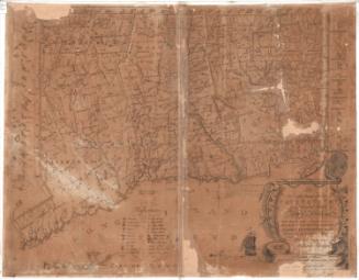
DescriptionMap of the city of Philadelphia, Pennsylvania, and 10 miles around it. The image area is circular, with concentric circles radiating out in one-mile increments. Counties and towns are labeled, and individual properties have been added by hand and include the owner's name and date of settlement. Schools, places of worship, "gentlemen's seats," taverns, bridges, and mills are marked with symbols. Physical features depicted include elevation, conveyed with hachure marks, the Schuylkill and Delaware Rivers, and other bodies of water. In the bottom left corner is a depiction of four putti with various surveying instruments and an allegorical figure, possibly representing geography, resting on a globe, holding a compass. In the bottom right corner is a depiction of four putti, one holding out a scroll to a figure wearing a war helmet, two using what appears to be a measuring device, and the fourth using what appears to be a compass. A Native American appears next to the helmeted figure and behind them is a ship bearing the Cowpens Flag (twelve stars arranged in a circle with one in the center). In the foreground are the Pennsylvania shield with a ship, a plow, and three sheaves of wheat, the New Jersey shield with three plows, and various farming tools and produce.
Object number2004.143.0
NotesCartographic Note: No scaleOn View
Not on view

Lucius Stebbins & Co.
1859

Joel Knott Allen
1791 or 1792