A Plan of the City of Philadelphia and Environs
DraftsmanDrawn by
John Hills
(American, active 1777 - 1817)
PrintmakerEngraved by
William Kneass
(American, 1780 - 1840)
Date1808
MediumEngraving; black printer's ink and watercolor on wove paper, lined with linen, in bound covers
DimensionsPrimary Dimensions (image height x width): 39 3/4 x 39 3/4in. (101 x 101cm)
Sheet (height x width): 40 3/4 x 41 1/4in. (103.5 x 104.8cm)
Mount (height x width): 40 3/4 x 41 1/4in. (103.5 x 104.8cm)
ClassificationsHardware
Credit LineConnecticut Museum of Culture and History collection
Object number2004.143.0
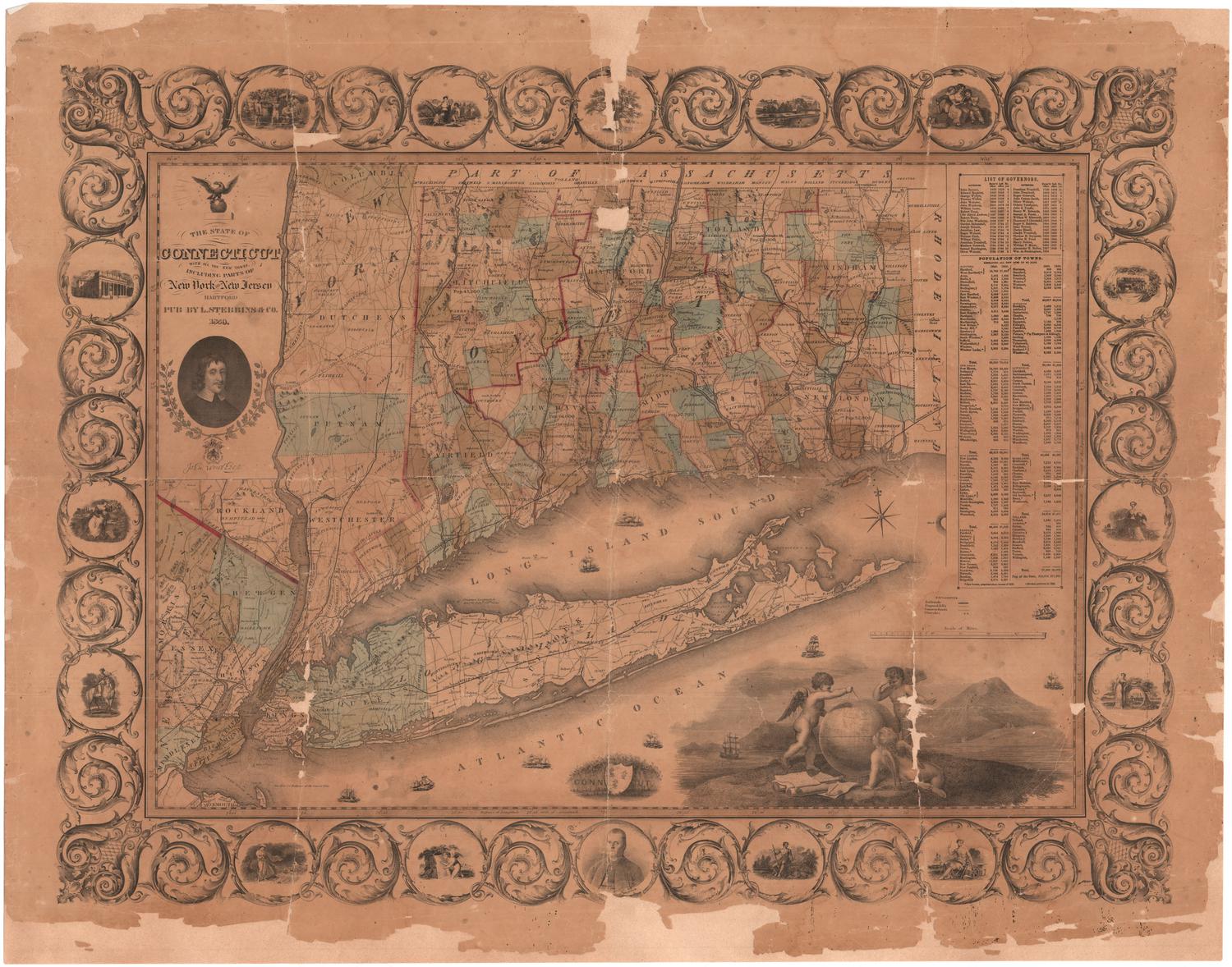
DescriptionMap of the city of Philadelphia, Pennsylvania, and 10 miles around it. The image area is circular, with concentric circles radiating out in one-mile increments. Counties and towns are labeled, and individual properties have been added by hand and include the owner's name and date of settlement. Schools, places of worship, "gentlemen's seats," taverns, bridges, and mills are marked with symbols. Physical features depicted include elevation, conveyed with hachure marks, the Schuylkill and Delaware Rivers, and other bodies of water. In the bottom left corner is a depiction of four putti with various surveying instruments and an allegorical figure, possibly representing geography, resting on a globe, holding a compass. In the bottom right corner is a depiction of four putti, one holding out a scroll to a figure wearing a war helmet, two using what appears to be a measuring device, and the fourth using what appears to be a compass. A Native American appears next to the helmeted figure and behind them is a ship bearing the Cowpens Flag (twelve stars arranged in a circle with one in the center). In the foreground are the Pennsylvania shield with a ship, a plow, and three sheaves of wheat, the New Jersey shield with three plows, and various farming tools and produce.
Label TextPhiladelphia served as the capital of the United States from 1790 to the end of 1800. Even after the capital moved to Washington, D.C., the city remained a major center of business and culture. Correspondence in the Connecticut Historical Society manuscript collection confirms that Connecticut citizens had contacts there. Connecticut vessels visited the city, and at least one Connecticut author sent a book to Philadelphia to be printed. John Hills's Plan of Philadephia is an impressive work of art that reflects the formal training he received in London before coming to America with the British army. The elaborate decorations include a charming depiction of winged putti with surveying instruments. Though such conceits were apparently common in Europe, they rarely appear on American maps.
NotesCartographic Note: No scaleStatus
Not on view

Lucius Stebbins & Co.
1859


Joel Knott Allen
1791 or 1792