Map of New Haven, Connecticut, and Vicinity
PublisherPublished by
Interstate Publishing Co., Inc.
(American, active 1950s-1960s)
DistributorDistributed by
First Federal Savings and Loan of New Haven
(American, founded 1934)
Datebefore 1962
MediumLithography; black printer's ink on wove paper, in paper covers
DimensionsPrimary Dimensions (image height x width): 26 3/8 x 20 3/4in. (67 x 52.7cm)
Sheet (height x width): 32 x 23 3/8in. (81.3 x 59.4cm)
Sheet (height x width): 32 x 23 3/8in. (81.3 x 59.4cm)
ClassificationsGraphics
Credit LineMuseum purchase
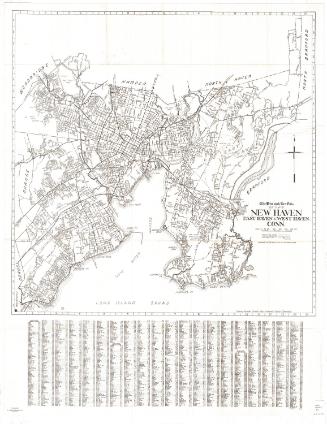
DescriptionPocket street map of New Haven, Connecticut, including Hamden, North Haven, West Haven, and Woodbridge. The New York, New Haven and Hartford Railroad runs through the city. Physical features include lakes and the West, Quinnipiac, East Haven, and Mill Rivers. In the center of the map is a vignette of the First Federal Savings and Loan Association building. There is a street index to the left of and below the map.
Object number2000.184.1
NotesCartographic Note: No scale
Date Note: The telephone number of the bank appears as MAin 4-9871. The Southern New England Telephone Company introduced all-number telephone numbers in 1962, eliminating exchange names.On View
Not on view

R. A. Welcke Offset Co.
probably 1967
Blum's Commercial Map Publishing Company
1927-1928