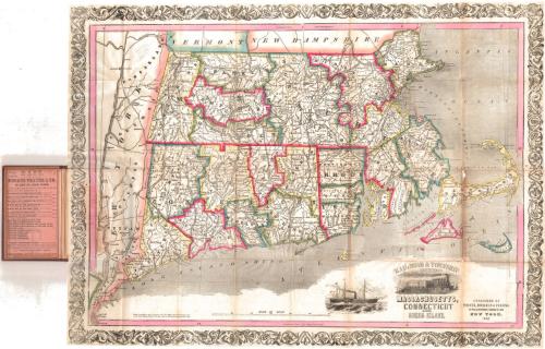
Rail-road and Township Map of Massachusetts, Connecticut and Rhode Island
PublisherPublished by
Thayer, Bridgman & Fanning
(American, active 1853)
Packaging MakerPackaging made for
Horace Thayer & Co.
(American, 1852)
Date1853
MediumLithography; black printer's ink and watercolor on wove paper, in cardboard covers
DimensionsPrimary Dimensions (image height x width): 20 1/8 x 27in. (51.1 x 68.6cm)
Sheet (height x width): 20 1/4 x 27 1/4in. (51.4 x 69.2cm)
Sheet (height x width): 20 1/4 x 27 1/4in. (51.4 x 69.2cm)
ClassificationsGraphics
Credit LineConnecticut Museum of Culture and History collection
DescriptionPocket map of Massachusetts, Connecticut and Rhode Island, with the borders of Vermont and New Hampshire to the north, the Atlantic Ocean to the east, the Long Island Sound to the south, and New York state to the west. The states are divided into counties, outlined in blue, red, green, or yellow, and subdivided into towns. Railroad lines are prominently depicted, although they are not labeled. Cities are indicated with groups of black squares. Physical features depicted include elevation, conveyed with hachure marks, rivers and lakes. The decorative cartouche shows a train with a town in the backgroun. To the left of this is a vignette of a large steamboat.
Object number1996.187.0
NotesCartographic Note: Scale: 1 1/8 inch equals 10 milesOn View
Not on view


H. F. Sumner & Co.
1833

