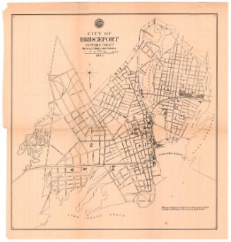
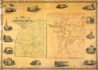
Map of the City of Bridgeport, Conn.
SurveyorSurveyed by
Sidney & Neff
(American, 1850 - 1855)
PhotographerVignettes after daguerreotypes by
C. S. Middlebrook
(American, born 1822)
PublisherPublished by
Collins & Clark
(American, active 1850 - 1851)
Date1850
MediumLithography; black printer's ink and watercolor on wove paper mounted on fabric
DimensionsPrimary Dimensions (image height x width): 37 x 35 3/4in. (94 x 90.8cm)
Sheet (height x width): 41 x 38 1/2in. (104.1 x 97.8cm)
Sheet (height x width): 41 x 38 1/2in. (104.1 x 97.8cm)
ClassificationsGraphics
Credit LineMuseum purchase - Robbins Fund
DescriptionMap of the city of Bridgeport, Connecticut, with the Old Stage Road to the north, East Bridgeport to the east, Long Island Sound to the south, and Fairfield to the west. The New York and New Haven Railroad, the Naugatuck Railroad, and the Housatonic Railroad intersect at the Bridgeport waterfront. Bridges cross Bridgeport Harbor and the Pequonnock River. Streets are named and names of property owners are indicated. Elevation is indicated by hachure marks. Vignettes at left and right depict the Bridgeport Foundry and Machine Company, the First Congregational Church, the Methodist Episcopal Church, the Reverend H. Jones's Cottage School, and the residences of H. K. Harral, Mrs. Adriance, N. S. Wordin, J. C. Loomis, E. B. Middlebrook, and Stephen Tomlinson. Iranistan, the residence of P. T. Barnum, is at upper left.
Object number1950.563.1
NotesCartographic Note: One inch equals 300 feetOn View
Not on view