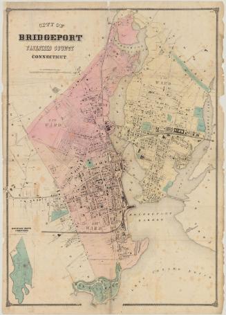
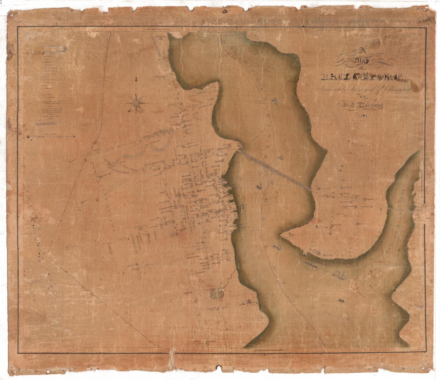
Map of the City of Bridgeport, Conn.
SurveyorSurveyed by
Sidney & Neff
(American, 1850 - 1855)
PhotographerVignettes after daguerreotypes by
C. S. Middlebrook
(American, born 1822)
PublisherPublished by
Collins & Clark
(American, active 1850 - 1851)
Date1850
MediumLithography; black printer's ink and watercolor on wove paper mounted on fabric
DimensionsPrimary Dimensions (image height x width): 37 x 35 3/4in. (94 x 90.8cm)
Sheet (height x width): 41 x 38 1/2in. (104.1 x 97.8cm)
ClassificationsGraphics
Credit LineMuseum purchase - Robbins Fund
Object number1950.563.1
DescriptionMap of the city of Bridgeport, Connecticut, with the Old Stage Road to the north, East Bridgeport to the east, Long Island Sound to the south, and Fairfield to the west. The New York and New Haven Railroad, the Naugatuck Railroad, and the Housatonic Railroad intersect at the Bridgeport waterfront. Bridges cross Bridgeport Harbor and the Pequonnock River. Streets are named and names of property owners are indicated. Elevation is indicated by hachure marks. Vignettes at left and right depict the Bridgeport Foundry and Machine Company, the First Congregational Church, the Methodist Episcopal Church, the Reverend H. Jones's Cottage School, and the residences of H. K. Harral, Mrs. Adriance, N. S. Wordin, J. C. Loomis, E. B. Middlebrook, and Stephen Tomlinson. Iranistan, the residence of P. T. Barnum, is at upper left.
Label TextWhile large town maps such as this one were based on surveys by itinerant surveyors, often from out of state, the surrounding small pictures (known as vignettes) were sometimes based on drawings by local artists. Sidney & Neff, whose surveys form the basis for this 1850 map of Bridgeport, Connecticut, were based in Philadelphia, but the vignettes are based on daguerreotypes by Charles S. Middlebrook, a young local photographer. Daguerreotypes were at the height of their popularity in 1850; they would soon be superceded by other less expensive forms of photography. Bridgeport in 1850 was growing rapidly. The combination of good rail and steamship transportation made it an ideal setting for heavy industry. At the same time, it retained many gracious homes--such as P. T. Barnum's Iranistan--in its outlying areas.
NotesCartographic Note: One inch equals 300 feetStatus
Not on view