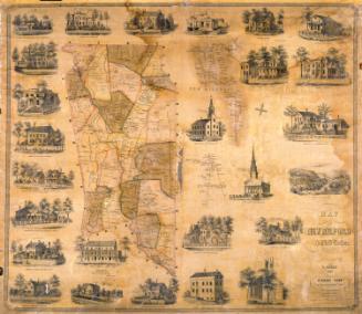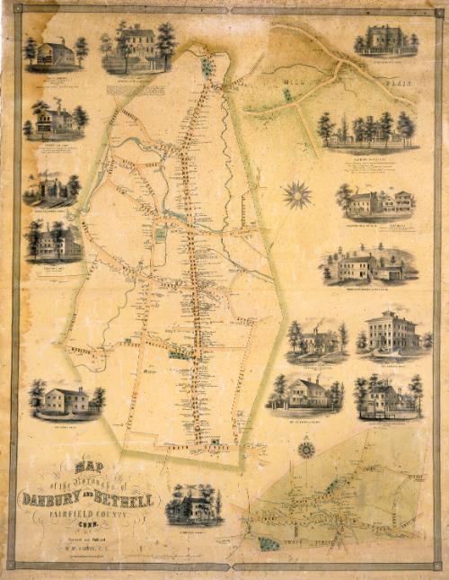
Map of the Boroughs of Danbury and Bethel, Fairfield County, Conn.
SurveyorSurveyed by
D. McCarthy
PrinterPrinted by
Friend & Aub
(American, founded 1852)
PublisherPublished by
D. McCarthy
Dateabout 1855
MediumLithography; black printer's ink and watercolor on wove paper mounted on fabric
DimensionsPrimary Dimensions (image height x width): 46 3/4 x 36 1/4in. (118.7 x 92.1cm)
Sheet (height x width): 49 1/2 x 38in. (125.7 x 96.5cm)
ClassificationsGraphics
Credit LineMuseum purchase - Hoadley Fund
Object number1948.21.1
DescriptionMap showing the boroughs of Danbury and Bethel and the village of Mill Plain. The position of the three separate maps does not appear to relate to the actual positions of the three communities. Streets are clearly identified and buildings are accompanied by the names of property owners. Streams are shown but not identified and elevation is not indicated. What appear to be cemeteries are colored green, with small willow trees. The vignettes surrounding the maps depict Clark's Cash Store, Lyman Keeler's Pahquioque Hotel, the new schoolhouse, Danbury Institute, the premises of Charles E. Andrews, manufacturer and dealer in stoves and tin, the Wooster Hotel, Charles Hull's residence and manufactory, Wildman and Fry's Hatforming Factory and Sawmill, and the residences of L. P. Hoyt, S. A. Hurlbut, P. A. Sutton, Frederick S. Wildman, G. W. Ives, and Mrs. Laura Barnum. Although hat factories do not figure prominently in the vignettes, the locations of several hat factories are indicated on the map itself.
Label TextMaps are meant to convey information and most maps contain quite a bit of information about themselves. This map of Danbury and Bethel, two towns in Fairfield County, Connecticut, contains remarkably little. The two communities are not even clearly identified (Danbury is at the upper left and Bethel at the lower right), though the village of Mill Plain (at upper right) is labeled. The map is undated, though it must date from the 1850s, when such large town maps were popular. The surveyor of the map, D. McCarthy, is known to have surveyed two other maps, published in 1854 and 1855. The fact that McCarthy published this map himself is also unusual. Most surveyors in this period worked for map publishers, who were responsible for the printing and distribution of the maps. This map appears to be extremely rare, so perhaps D. McCarthey's venture into publishing was not too successful.
NotesCartographic Note: One inch equals fifteen perches. A perch is an almost obsolete unit of measurement. The exact length of perch varies from country to country. Since the surveyor of this map was apparently of Irish origin, perhaps he used the Irish perch which equals twenty-one feet. The perch was never a standard unit of measure in the United States.Status
Not on view