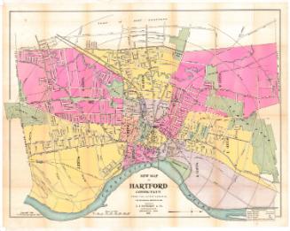
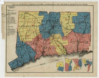
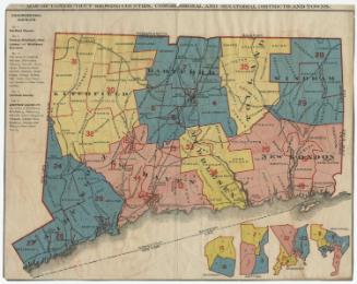
New Map of Hartford from the Latest Surveys
PrintmakerLithographed by
Kellogg & Bulkeley
(American, 1867 - 1990)
PublisherPublished by
Elihu Geer
(American, 1817 - 1887)
Date1877
MediumLithography; black printer's ink and watercolor on wove paper, in cardboard covers
DimensionsPrimary Dimensions (Map of Hartford image height x width): 10 x 18 3/4in. (25.4 x 47.6cm)
Sheet (Map of Hartford height x width): 10 1/2 x 19in. (26.7 x 48.3cm)
ClassificationsGraphics
Credit LineMuseum purchase
Object number1976.131.4b
DescriptionTwo maps within one set of covers. The main map is a pocket map of Connecticut and the other map, described here, is a pocket map of Hartford, with Bloomfield to the north, East Hartford to the east, Wethersfield to the south, and West Hartford to the west. The city is divided into wards, colored pink, blue or yellow, and each contains a number that represents the location of that ward's voting place. Green is used to depict parks and cemeteries. The Hartford and New Haven; Hartford, Providence and Fishkill; Connecticut Western; and Connecticut Valley Railroad lines run through town. There are concentric circles in one-half mile increments from Union Station.
Label TextWhy would maps by two different Hartford publishers be sold together in the same binding? This map of Hartford published by Elihu Geer. was bound together with a map of Connecticut published by Hamersley & Co. Both were long-established Hartford firms and presumably business rivals. The probable explanation is that William James Hamersley, the principal partner in Hamersley & Co. died suddenly in May 1877. Following his death, his business was dissolved and the entire contents of his store and printing establishment were sold. Somebody--perhaps Geer, perhaps a third party--must have purchased his stock of maps of Connecticut and decided that combining them with maps of Hartford would make an attractive package to sell to travelers.
NotesCartographic Note: Scale: 1 inch equals 1500 feetStatus
Not on view


Kellogg & Bulkeley
1910-1915
Kellogg & Bulkeley
1915-1920