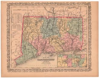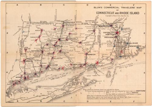
Blum's Commerical Travelers' Map of Connecticut and Rhode Island
PublisherPublished by
Blum's Commercial Map Publishing Company
(American, founded 1910)
Date1927-1928
MediumLithography; black printer's ink on wove paper, in paper covers
DimensionsPrimary Dimensions (image height x width): 9 x 12 5/8in. (22.9 x 32.1cm)
Sheet (height x width): 9 1/2 x 13 5/8in. (24.1 x 34.6cm)
ClassificationsGraphics
Credit LineMuseum purchase
Object number1993.174.1
DescriptionPocket map of Connecticut and Rhode Island, with the borders of Massachusetts to the north and east, Long Island and the Long Island Sound to the south, and the border of New York to the west. Main and branch railroad lines, predominantly of the New York, New Haven and Hartford Railroad (marked N.H.), are prominently depicted on the map, with stations marked in circles and figures that are probably distances between stations shown. The other railroad line shown is the Central New England. Interurban trolley routes and steam boat routes in the Long Island Sound and Narragansett Bay are also shown. On the inside covers and back of the map are hotel directories by town for Connecticut and Rhode Island that contain information about hotels' rates, the town's population, the hotels' locations, and the local industry. Following the directories are lists of cities in each state having populations of less than 5,000, and lists of the legal holidays. On the back of the cover is a guide for how to use the map.
Label TextDespite the advent of the private automobile, public transportation was still widely used by business traveleers in the 1920s. This map provides detailed information about train, trolley, and steamboat routes. By this date, the New York, New Haven, and Hartford Railroad had a virtual monolopy of rail transport in Connecticut. This copy of the map has been marked with red x's and blue o's by an early owner, probably someone who did business in the towns that are marked. The New York map publisher Max. L. Blum specialized in publishing maps for travelers. His firm's motto was "Blum's maps make all traveling easy."
NotesCartographic Note: No scaleStatus
Not on view