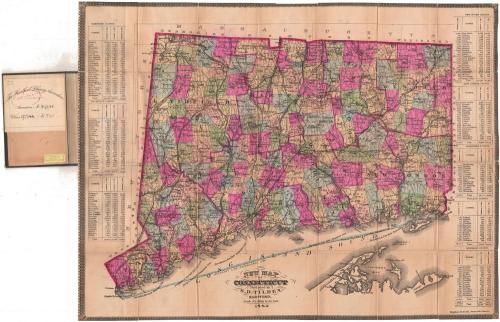
New Map of Connecticut
PublisherPublished by
Samuel D. Tilden
(American, 1828 - 1893)
PrintmakerLithographed by
Bingham & Dodd
(1860 - 1878)
Date1882
MediumLithography; black printer's ink and watercolor on wove paper, mounted on paper, in cardboard covers
DimensionsPrimary Dimensions (image height x width): 20 1/4 x 26 1/2in. (51.4 x 67.3cm)
Sheet (height x width): 20 1/4 x 26 1/2in. (51.4 x 67.3cm)
Mount (height x width): 20 1/4 x 26 1/2in. (51.4 x 67.3cm)
ClassificationsGraphics
Credit LineConnecticut Museum of Culture and History collection
Object number1991.195.0
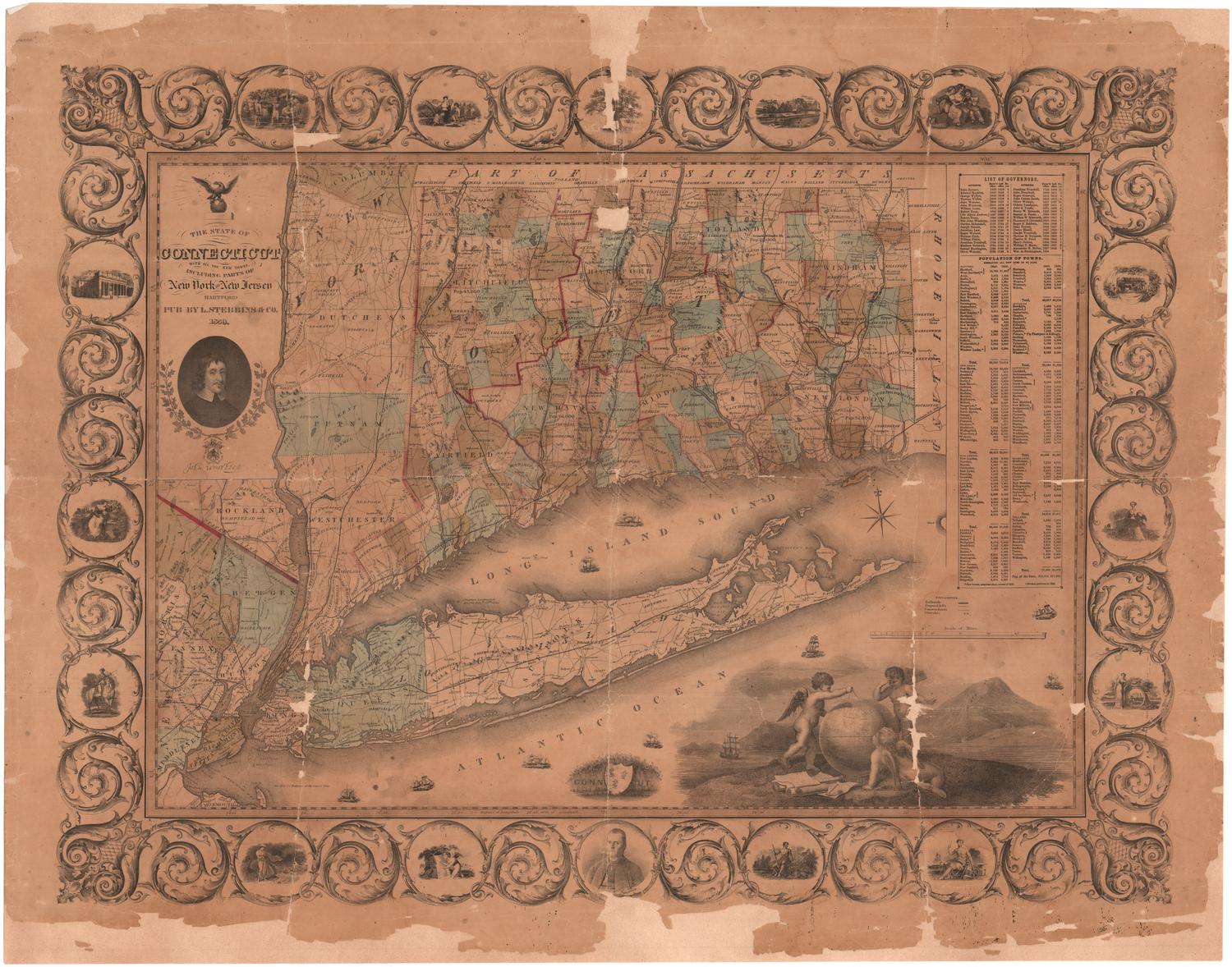
DescriptionPocket map of Connecticut, with the border of Massachusetts to the north, Rhode Island to the east, part of Long Island and the Long Island Sound to the south, and New York to the west. County divisions are shown in broken solid and dotted lines and outlined in bright pink, while towns are outlined in broken solid lines and colored blue, green, pink, yellow, or peach. Roads are shown. The New York, New Haven and Hartford; Portchester and Ridgefield; Housatonic; Naugatuck; New Haven and Northampton; Boston and New York Air Line; Connecticut Western; Hartford, Providence and Fishkill; Connecticut Valley; New London Northern; and Norwich and Worcester Railroad lines are all shown. Physical features depicted include rivers and lakes/ponds. In Long Island Sound, the "BOUNDARY LINE ESTABLISHED 1880" is prominently featured. Lists of towns with their populations in 1860, 1870, and 1880 are at left and right of the map.
Label TextThe prolific map publisher Samuel D. Tilden re-issued his "New Map of Connecticut" frequently during the 1870s and 1880s, updating it as necessary to show new towns as they were incorporated. He clearly hoped that issuing a "new map" virtually every year would encourage purchasers to replace their old maps, in order to remain up-to-date. The unique thing about this 1882 map is the prominent "Boundary Line" running through Long Island Sound. Although Connecticut gave up its claims to eastern Long Island in the seventeenth century, the exact position of the boundary dividing Connecticut from New York State had never been determined. In 1880, a joint commission of the two states finally decided exactly where the boundary line should be drawn.
NotesCartographic Note: Scale: 1 inch equals 4 1/2 milesStatus
Not on view


Kellogg & Bulkeley
1910-1915
Lucius Stebbins & Co.
1859