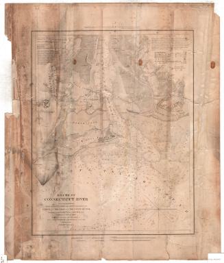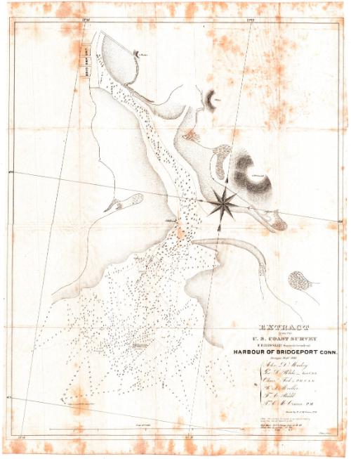
Harbour of Bridgeport, Connecticut
SurveyorSurveyed by
George S. Blake
(American, 1802 - 1871)
SurveyorSurveyed by
Thomas A. Budd
(American, died 1862)
SurveyorSurveyed by
Tunis A. M. Craven
(American, 1813 - 1864)
SurveyorSurveyed by
Oliver Tod
(American, 1811 - 1845)
SurveyorSurveyed by
Alex. Mackey
SurveyorSurveyed by
B. S. Moeller
DraftsmanDrawn by
Tunis A. M. Craven
(American, 1813 - 1864)
MakerUnder the direction of
Ferdinand Rudolph Hassler
(American, 1770 - 1843)
WriterText written by
George S. Blake
(American, 1802 - 1871)
PrinterPrinted by
P. Haas
(American, active 1837 - 1845)
PublisherPublished by
United States Coast Survey
(American, founded 1807)
Date1835
MediumLithography; black printer's ink on wove paper
DimensionsPrimary Dimensions (image height x width): 27 1/2 x 22in. (69.9 x 55.9cm)
Sheet (height x width): 29 3/8 x 22 1/2in. (74.6 x 57.2cm)
Sheet (height x width): 29 3/8 x 22 1/2in. (74.6 x 57.2cm)
ClassificationsGraphics
Credit LineConnecticut Museum of Culture and History collection
DescriptionChart of the harbor in Bridgeport, Connecticut, with soundings at low tide in feet. The surrounding land is not depicted in much detail, although elevation and what appears to be swampland are both conveyed. An accompanying report shows that the chart was drafted to suggest an improvement to the harbor by dredging that would allow for greater access by commercial vessels.
Object number1991.194.0
NotesCartographic Note: Scale: 12 1/2 inches equals 1 mileOn View
Not on view