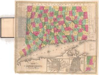
Connecticut
PrintmakerEngraved by
Unknown
PublisherPublished by
Unknown
DateProbably 1807
MediumEngraving; black printer's ink and watercolor on wove paper, in cardboard covers
DimensionsPrimary Dimensions (image height x width): 7 1/4 x 9 1/8in. (18.4 x 23.2cm)
Sheet (height x width): 8 1/2 x 10 1/4in. (21.6 x 26cm)
ClassificationsGraphics
Credit LineConnecticut Museum of Culture and History collection
Object number1986.290.0
DescriptionPocket map of the state of Connecticut, with Massachusetts to the north, Rhode Island to the east, part of Long Island and the Long Island Sound to the south, and New York to the west. The state is divided into counties, colored pink, green, yellow or blue. Main roads are depicted, as are railroads, including the New York and New Haven; Naugatuck; Housatnoic; New Haven and Northampton; Hartford and Profidence; and Willimantic to Palmer Railroads. Physical features depicted include elevation, conveyed with hachure marks; rivers; and lakes.
Label TextThis small map of Connecticut was probably published in 1807 or early 1808. Two new towns were incorporated in 1807, North Stonington and Middlebury. North Stonington appears on the map and Middlebury does not. Nineteenth-century maps of Connecticut were not necessarily always up-to-date, however. New towns were being added with great frequency, and map publishers, especially those outside Connecticut, didn't always bother to keep up. Therefore the presence or absence of a given town on a given map is only rough guide to its probable date of publication. Though similar to many other maps of Connecticut from the early decades of the nineteenth century, this maps does not exactly corrrespond to any other map in the Connecticut Historical Society's collection.
NotesCartographic Note: Scale: 1 inch equals about 10 1/2 milesStatus
Not on view