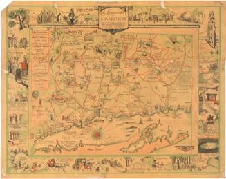
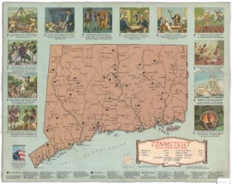
Map of Connecticut, Issued in Commemoration of the State's Tercentenary
DraftsmanDrawn by
John Held Jr.
(American, 1889 - 1958)
PublisherPublished by the
Aetna Casualty and Surety Company
(American, founded 1917)
Date1935
MediumOffset lithography; black and colored printer's inks on wove paper
DimensionsPrimary Dimensions (image height x width): 17 1/4 x 23in. (43.8 x 58.4cm)
Sheet (height x width): 18 x 31 7/8in. (45.7 x 81cm)
Sheet (height x width): 18 x 31 7/8in. (45.7 x 81cm)
ClassificationsGraphics
Credit LineGift of Mrs. John A. Campbell
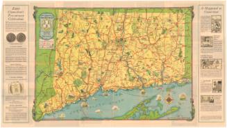
DescriptionFolding map of the state of Connecticut, with the Long Island Sound to the south and New York to the west. The map marks the state's major highways and uses pictures to show the locations of historic sites, including battles and notable homes and schools. Text on both sides of the image describes the significance of the pictures. On the verso are photographs and text about some of Connecticut's landmarks, a memo from the governor, and sketches of the seventeen original towns.
Object number1983.195.1
NotesCartographic Note: No scaleOn View
Not on view