
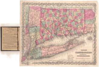
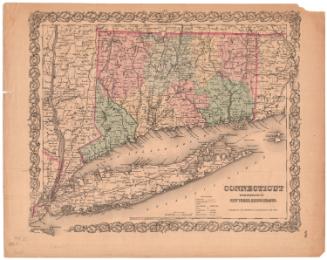
Colton's Connecticut, with portions of New York and Rhode Island
PublisherPublished by
G.W. & C.B. Colton & Co.
(American, founded 1865)
After a work byAfter a work by
J. H. Colton & Co.
(American, founded 1831)
Date1868
MediumLithography; black printer's ink and watercolor on wove paper, in cardboard covers
DimensionsPrimary Dimensions (image height x width): 12 3/4 x 15 1/4in. (32.4 x 38.7cm)
Sheet (height x width): 13 1/4 x 15 7/8in. (33.7 x 40.3cm)
ClassificationsGraphics
Credit LineGift of Mrs. Malvina Stevens
Object number1983.193.0
DescriptionPocket map of Connecticut, with western Rhode Island, Long Island and eastern New York. State boundaries are outlined in red, and Connecticut's counties are also outlined in red. The state is further divided into towns, colored pink, green, or yellow. Railroads and common roads are depicted on the map. Railroad lines include New York and New Haven; Danbury and Norwalk; Housatonic; Naugatuck; New Haven and Northampton; Hartford, Providence and Fishkill; New Haven, Hartford and Springfield; New Haven and New London; Norwich and Worcester; and New London, Willimantic and Palmer. The New York and Boston Air Line is marked with a different line, possibly indicating a proposed railroad. Cities are depicted with clusters of dots, and county towns, towns and villages are represented with different circles. Physical features include elevation, conveyed with hachures marks; rivers; and ponds and lakes.
Label TextThe Connecticut Historical Society has numerous editions of this map of Connecticut, which first appeared in Colton's Atlas of the World, published in New York by J. H. Colton & Co. in 1855. Over the next twenty years, the same map was repeatedly reissued by Colton and his sons. It is interesting to compare the different editions and to note just how rarely changes were made, even though many new towns were being added to Connecticut during this period. This 1868 edition appears to be virtually identical with the 1867 and 1869 editions. Only the dates have been changed. None of the maps includes the towns of Sprague, incorporated in 1861, or Middlefield, incorporated in 1866. On all three, the last new town to appear is Morris, which was incorporated in 1859.
NotesCartographic Note: Scale: 1 inch equals 10 milesStatus
Not on view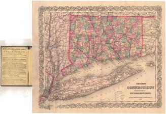


Kellogg & Bulkeley
1910-1915