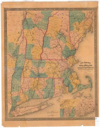
Colton's Vermont
PublisherPublished by
J. H. Colton & Co.
(American, founded 1831)
Date1860
MediumLithography; black printer's ink and watercolor on wove paper, in cardboard covers
DimensionsPrimary Dimensions (image height x width): 15 1/4 x 12 3/4in. (38.7 x 32.4cm)
Sheet (height x width): 16 1/4 x 13 3/4in. (41.3 x 34.9cm)
ClassificationsGraphics
Credit LineConnecticut Museum of Culture and History collection
Object number1977.122.0
DescriptionPocket map of the state of Vermont, with Canada to the north, New Hampshire to the east, Massachusetts to the south, and New York to the west. The state is outlined in dark pink and is divided into counties, colored pink, green, yellow and peach. Towns are outlined in thin solid lines. Railroad lines depicted include Western Vermont; Cheshire; Rutland and Burlington; Rutland and Washington; Vermont Central; Passumpsic; and the Portland Branch of the Grand Trunk. Common roads are also shown. Physical features include elevation, conveyed with hachure marks; lakes; and rivers.
Label TextMany of Vermont's original settlers came from Connecticut, and when Vermont declared its independence from Great Britain in 1777, it initially took the name "New Connecticut." The connection between the two states remained strong, and the earliest maps of Vermont were engraved and printed in Connecticut. This long historical relationship between the two states probably meant little to the New York publisher who produced this 1860 map or to the business travelers and tourists who purchased it to assist them in planning their journeys.
NotesCartographic Note: Scale: 3/8 inch equals 5 milesStatus
Not on view