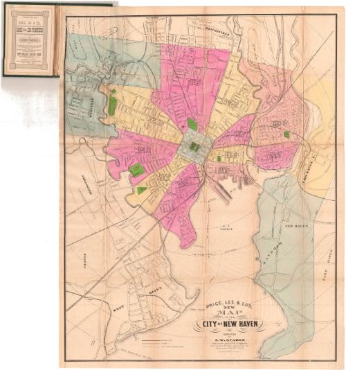
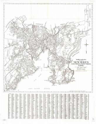
Price, Lee & Co.'s New Map of the City of New Haven
SurveyorSurveyed by
Silus W. Searle
(American, 1822 - 1902)
DraftsmanDrawn by
Silus W. Searle
(American, 1822 - 1902)
PublisherPublished by
Price & Lee Co.
(American)
Dateafter 1873
MediumLithography; black printer's ink and watercolor on wove paper, in cardboard covers
DimensionsPrimary Dimensions (image height x width): 28 x 21 7/8in. (71.1 x 55.6cm)
Sheet (height x width): 29 3/8 x 22 7/8in. (74.6 x 58.1cm)
ClassificationsGraphics
Credit LineMuseum purchase
Object number1977.121.1
DescriptionPocket map of the city of New Haven, Connecticut, with Whitneyville to the north, East Haven to the east, the harbor to the south, and Allington to the west. The city is divided into wards, each colored pink, yellow, blue or peach. Westville and Raynham are colored blue, and Fair Haven East is colored yellow. Parks and cemeteries are colored green. City streets are shown and labeled, along with some buildings, including Yale, City Hall, and two hospitals. Steam railroad lines shown include the New York, New Haven and Hartford; New Haven and Derby; New Haven and Northampton; Shore Line; and the New York and Boston Air Line. Horse railroads ran along Kimberly Avenue, Howard and Sylvan Avenues, Chapel Street, Grand Street, Shelton Avenue (New Haven and Centerville Horse Railroad), Whitney Avenue (New Haven and Whitneyville Horse Railroad) and Meadow Street. There are concentric circles from city hall in one-mile increments.
Label TextThis map of New Haven, Connecticut is notable for the prominence of the "horse railroads," a form of public transportation utilizing horse-drawn streetcars running on tracks. Although the idea originated in the early nineteenth century, horse cars really only became popular in the 1870s and 1880s. As this map shows, New Haven's horse car system was quite extensive. The heyday of the horse railroad was brief. By the 1890s, horse cars were being replaced by electric trolleys in most cities.
NotesCartographic Note: Scale: 1 inch equals 1200 feetStatus
Not on view


R. A. Welcke Offset Co.
probably 1967