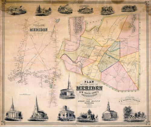
Plan of the Town of Meriden, New Haven County, Connecticut
SurveyorSurveyed by
E. M. Woodford
(American, 1824 - 1862)
PrinterPrinted by
Wagner & McGuigan
(American, 1845 - 1859)
PublisherPublished by
Richard Clark
(American)
Date1851
MediumLithography; black printer's ink and watercolor on wove paper mounted on fabric
DimensionsPrimary Dimensions (image height x width): 35 x 42 1/2in. (88.9 x 108cm)
Sheet (height x width): 36 3/4 x 43 1/2in. (93.3 x 110.5cm)
ClassificationsGraphics
Credit LineConnecticut Museum of Culture and History collection
Object number2012.312.285
DescriptionMap of the town of Meriden, Connecticut, with Berlin to the north, Middletown to the east, Wallingford to the south, and Cheshire and Southington to the west. the town is divided into twelve districts. Roads, turnpikes (with turnpike gates), and the New Haven, Hartford, and Springfield Railroad are shown. Names of property owners are indicated. Cemeteries are colored green. Streams and mountains are shown. Elevation is indicated by hachure marks; ridges are outlined. An adjoining map depicts the village of Meriden and part of West Meriden and provides more detail, including names of local streets, churches, businesses, and additional property owners. Vignettes at top and bottom depict the First Congregational Church, the Center Congregational Church, the Baptist Church, the Methodist Church, St. Andrew's Episcopal Church, the Union Works, Curtiss, Morgan and Company's Lock Manufactory and Iron-Foundry, Curtis L. North's store, Julius Andrews's Hemlock Grove, Curtis L. North's residence and insurance office, and the residences of Jedediah Wilcox, H. W. Curtiss, and Levi Allen.
Label TextMeriden, Connecticut occupies a dramatic setting, dominated by the Hanging Hills to the north. Surveyor Edgar M. Woodford had difficulty depicting these rugged traprock ridges and used a combination of hachure marks and outlines in an attempt to indicate their height. Contour intervals, frequently used to today to accurately indicate elevation, did not come into use until after the Civl War. In 1851, Meriden was still a small village, but in 1852, several small silver plate factories would be consolidated to form the Meriden Britannia Company and the little village would be well on its way to becoming "Silver City."
NotesCartographic Note: One inch equals thirty rods (Plan of town of Meriden). Three inches equals 1000 feet (Village of Meriden)Status
Not on view