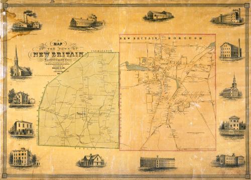
Map of the Town of New Britain, Hartford County, Conn.
SurveyorSurveyed by
E. M. Woodford
(American, 1824 - 1862)
PrinterPrinted by
Wagner & McGuigan
(American, 1845 - 1859)
PublisherPublished by
Richard Clark
(American)
Date1851
MediumLithography; black printer's ink and watercolor on wove paper mounted on fabric
DimensionsPrimary Dimensions (image height x width): 30 5/8 x 43in. (77.8 x 109.2cm)
Sheet (height x width): 33 1/2 x 44in. (85.1 x 111.8cm)
ClassificationsGraphics
Credit LineConnecticut Museum of Culture and History collection
Object number2012.312.283
DescriptionMap of the town of New Britain, Connecticut at the left, with Farmington to the north, Wethersfield to the east, Berlin to the south, and Southington and Farmington to the west.; map of the borough of New Britain at the right. Roads and streets are shown and named within the borough. Names of property owners are indicated in the detailed map of the borough and in outlying sections of the town on the other map. The Hartford, Providence, and Fishkill Railroad appears on both maps. Ponds and streams are shown but not named. Elevaton is not indicated. Vignettes surrounding the maps depict Argillo Furnace, Russel, Erwin and Company; Russel and Erwin's Moulding Shop; Russel and Erwin's Office and Packing Room; Russel and Erwin's Lock Factory; Russel and Erwin's Finishing Room; the New Britain Knitting Company; the North Congregational Church; the Episcopal Church; the Normal School; Humphrey House; and the residences of I. N. Lee, F. H. North, F. T. Stanley, and T. W. Stanley.
Label TextNew Britain in 1851 was on the brink of great expansion. The industrial heart of town was incorporated as a separate borough in 1850, the same year that Russel and Erwin bought the Argillo Works of Albany, New York, and the local hardware business of North and Stanley. The factories of Russel and Erwin figure prominently, both on the borough map and in the surrounding vignettes. The factory buildings themselves are still relatively small, but there would soon be larger buildings as the company continued to expand. Other important New Britain manufacturers were also getting started. The Stanley Works would be incorporated in 1852, P. F. Corbin and Company in 1853. The borough of New Britain would be incorporated as a city in 1870; the city and town would be consolidated in 1905.
This map, one of the earliest of the large city and town maps published by Richard Clark in Philadelphia, was evidently something of an experiment, and its layout is not entirely successful. The relationship between the borough map and the town map (of which it is actually a detail) is not clearly articulated, and even the placement of the title seems awkward and tentative. Though some of Clark's other early maps use this same format, the maps published later in the 1850s are much sophisticated and attractive.
NotesCartographic Note: One inch equals approximatley 20 rods (for map of borough); no scale given for map of townThis map, one of the earliest of the large city and town maps published by Richard Clark in Philadelphia, was evidently something of an experiment, and its layout is not entirely successful. The relationship between the borough map and the town map (of which it is actually a detail) is not clearly articulated, and even the placement of the title seems awkward and tentative. Though some of Clark's other early maps use this same format, the maps published later in the 1850s are much sophisticated and attractive.
Status
Not on view