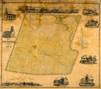
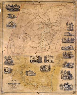
Map of the Town of Torrington, Litchfield, County, Connecticut
SurveyorSurveyed by
John Houston
PrintmakerLithographed by
Friend & Aub
(American, founded 1852)
PublisherPublished by
Richard Clark
(American)
Date1852
MediumLithography; black printer's ink and watercolor on wove paper mounted on fabric
DimensionsPrimary Dimensions (image height x width): 32 5/8 x 43 3/8in. (82.9 x 110.2cm)
Sheet (height x width): 35 1/4 x 46 1/4in. (89.5 x 117.5cm)
ClassificationsGraphics
Credit LineConnecticut Museum of Culture and History collection
Object number2012.312.281
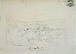
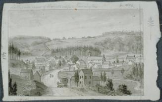
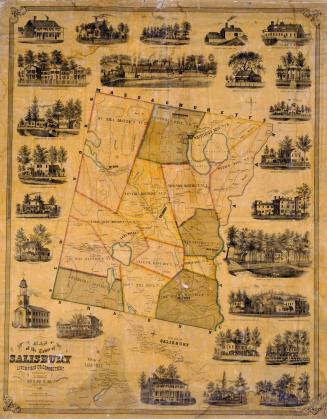
DescriptionMap of Torrington, Connecticut, with Winchester to the north, New Hartford to the east, Harwinton and Litchfield to the south, and Goshen to the west. The Naugatuck River, the East Branch River, and an unnamed lake are colored blue. Other rivers and streams are shown. Elevation is indicated by hachure marks. Roads, including turnpikes and turnpike gates are shown and locations of buildings are indicated with names of property owners. The villages of Wolcottville, Torrington, Torrington Hollow, Torringford, Newfield, Daytonville, and Burrville are shown. The Naugatuck Railroad runs through Wolcottville, Daytonville, and Burrville. A separate inset map provides additional detail for Wolcottville village. Vignettes at top and bottom depict the Union Manufacturing Company, Wolcottville Knitting Company, Wadham's Manufacturing Company, Alvord Carriage Manufacturing Company, A. & J. Dayton's Organ Manufactory, and the residences of Wadhams, James H. Tuttle, Milo Burr, Henry Colt, Daniel Robertson, and Leverett Tuttle.
Label TextIn the nineteenth century, the steep terrain evident on this map encouraged the development of several separate villages within the town of Torrington, Connecticut, and abundant water power from the swiftly flowing rivers led to rise of local industries. The coming of the Naugatuck Railroad in 1849 determined which villages would prosper. The railroad ran through Wolcottville, Daytonville, and Burrville, providing a fast and easy way for factories in those towns to ship their goods, and bypassed the original village of Torrington. Significantly, all of the factories that appear in the vignettes on this 1852 map were located in Wolcottville, and the inset map provides a detailed view of that village. During the 1860s and 1870s, Wolcottville continued to thrive and grow, and in 1881, it assumed the name of Torrington. The original village of Torrington was subsequently known as West Torrington.
NotesCartographic Note: 3 1/2 inches equals 70 rodsStatus
Not on view