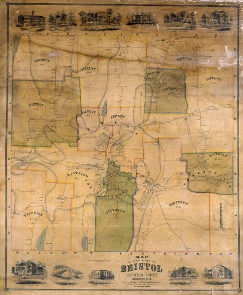
Map of the Town of Bristol, Hartford County, Connecticut
SurveyorSurveyed by
E. M. Woodford
(American, 1824 - 1862)
PrinterPrinted by
Wagner & McGuigan
(American, 1845 - 1859)
PublisherPublished by
Richard Clark
(American)
Date1852
MediumLithography; black printer's ink and watercolor on wove paper mounted on fabric
DimensionsPrimary Dimensions (image height x width): 41 3/4 x 34 1/4in. (106 x 87cm)
Sheet (height x width): 44 1/4 x 37 1/4in. (112.4 x 94.6cm)
ClassificationsGraphics
Credit LineMuseum purchase
Object number1956.95.3
DescriptionMap of the town of Bristol, Connecticut, with Burlington to the north, Farmington to east, Wolcott and Southington to the south, and Plymouth to the west. The town is divided into twelve districts. The southeastern district is shown as "ANNEXED TO PLAINVILLE DISTRICT." Swamps, ponds, streams, and hills are shown. Elevation is indicated by hachure marks. The Providence, Hartford and Fishkill Railroad runs through town. Roads, including a "proposed road," are shown. Houses and businesses are shown with names of property owners. Vignettes along the upper and lower margins depict A. N. Platt and Company's Clock and Spring Manufactory, the Bristol Mining Company, Foote's Hotel, and the residences of E. O. Goodwin, L. Hubbard, Almon Lewis, Charles T. Foote, S. H. Carrington, R. E. Manross, E. L. Dunbar, and J. C. Brown.
Label TextBristol was originally part of the town of Farmington. It was incorporated as a separate town in 1785. Even so, its borders evidently were not entirely fixed. This map shows an area in the southeast part of town that was "annexed to the Plainville District." Neighboring Plainville was still a part of Farmington--it would not be incorporated as a separate town until 1869--so Bristol was in effect returning the property to its mother town. Although this map was surveyed and probably drawn by E.M. Woodford of nearby Avon, Connecticut, it was printed and published in Philadelphia. The Philadelphia lithographers Wagner and McGuigan proudly noted that they used steam lithographic presses, a technological advance that enabled them to print large maps such as this one. Even so, the map was printed on two sheets, which were mounted together on a fabric backing.
NotesCartographic Note: One inch equals 50 rodsStatus
Not on view