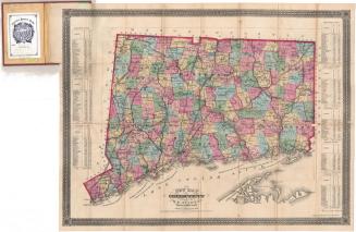
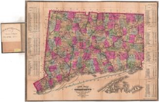
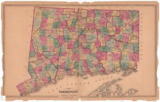
Map of Connecticut
PrintmakerLithographed by
Kellogg & Bulkeley
(American, 1867 - 1990)
PublisherPublished by
Hamersley & Co.
(American, 1868 - 1877)
Date1875-1877
MediumLithography; black printer's ink and watercolor on wove paper, in cardboard covers
DimensionsPrimary Dimensions (image height x width): 18 x 23 3/8in. (45.7 x 59.4cm)
Sheet (height x width): 19 7/8 x 27 7/8in. (50.5 x 70.8cm)
ClassificationsGraphics
Credit LineMuseum purchase
Object number1976.131.4a
DescriptionTwo maps within one set of covers. The main map is a pocket map of Connecticut, with the border of Massachusetts to the north, the border of Rhode Island to the east, part of Long Island and the Long Island Sound to the south, and the border of New York to the west. The state and its counties are outlined in red, with towns colored pink, yellow, blue or green. Railroad lines shown include Danbury and Norwalk; Boston, Hartford and Erie; Housatonic; Shepaug; Naugatuck; New Haven, Hartford and Springfield; Hartford, Providence and Fishkill; New Haven and Northampton; Connecticut Valley; New York and Boston Air Line; New London Northern; and Norwich and Worcester. Roads are also shown, and cities are depicted as small grids. Physical features include rivers and lakes/ponds.
Label TextWhy would maps by two different Hartford publishers be sold together in the same binding? This map of Connecticut published by Hamersley & Co. was bound together with a map of Hartford published by Elihu Geer. Both were long-established Hartford firms and presumably business rivals. The probable explanation is that William James Hamersley, the principal partner in Hamersley & Co. died suddenly in May 1877. Following his death, his business was dissolved and the entire contents of his store and printing establishment were sold. Somebody--perhaps Geer, perhaps a third party--must have purchased his stock of maps of Connecticut and decided that combining them with maps of Hartford would make an attractive package to sell to travelers.
NotesCartographic Note: Scale: 1 inch equals 4 1/2 milesDate Note: This map is virtually identical with 1949.20.2. That map is accompanied by a booklet indicating that it was published in 1875, despite the fact that the towns of Newington, incorporated in 1871, and Thomaston, incorporated in 1875, do not appear on it. On this map, the name of Newington has been clumsily added, overlapping part of the name of Wethersfield, its parent town, and the publisher's imprint has also been altered. It is clearly a later state, but just when it was issued is unclear. If it were printd after 1875, it is difficult to understand why Thomaston would not also have been added.
Status
Not on view