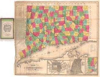
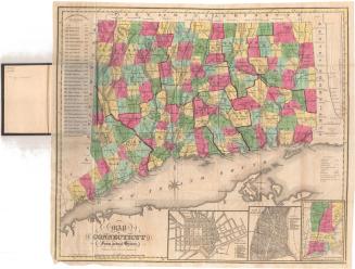
Connecticut
PublisherPublished by
John Warner Barber
(American, 1798 - 1885)
DateProbably 1852
MediumEngraving; black printer's ink and watercolor on wove paper, in cardboard covers
DimensionsPrimary Dimensions (image height x width): 7 3/8 x 9 1/8in. (18.7 x 23.2cm)
Platemark (height x width): 8 7/8 x 10 5/8in. (22.5 x 27cm)
Sheet (height x width): 9 1/4 x 11 3/4in. (23.5 x 29.8cm)
ClassificationsGraphics
Credit LineMuseum purchase
Object number1976.131.1
DescriptionPocket map of Connecticut, with the border of Massachusetts to the north, the border of Rhode Island to the east, part of Long Island and the Long Island Sound to the south, and part of New York State to the west. The state is divided into counties, colored yellow, pink or green. Physical features depicted include elevation, conveyed with hachure marks; rivers; and lakes/ponds. Roads are marked with parallel lines. Railroads depicted include the New York and New Haven; Naugatuck; New Haven and Northampton; and Hartford and Providence. There are also several unnamed lines, including the Danbury and Norwalk; Housatonic; what is probably New Haven and Hartford; what is probably New London, Willimantic and Palmer; and Norwich and Worcester. The New York and Boston Air Line is marked as "contemplated."
Label TextThe New Haven artist, author, and wood engraver, John Warner Barber produced many maps and views of Connecticut throughout his long and productive lifetime. This little folding pocket map of Connecticut was probably published in 1852, since Essex, which was incorporated in that year, is the latest town to appear in it. For a small map, it includes a great deal of accurate detail, though some of the railroad lines are not named and its seems that this would have been useful and even necessary information for a traveler using the map to find his way around Connecticut.
NotesCartographic Note: Scale: 7/8 inch equals 10 milesStatus
Not on view
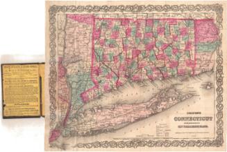
Lucius Stebbins & Co.
1859