A Map of Norwich, from actual survey
SurveyorSurveyed by
William Lester Jr.
PrintmakerEngraved by
S. Stiles & Co.
(American, 1833 - 1835)
PrinterPrinted by
S. Stiles & Co.
(American, 1833 - 1835)
PublisherPublished by
Thomas Robinson
(American, born about 1797)
Date1833
MediumEngraving; black printer's ink and watercolor on wove paper, in cardboard covers
DimensionsPrimary Dimensions (image height x width): 28 1/8 x 18 1/2in. (71.4 x 47cm)
Sheet (height x width): 29 3/8 x 19 7/8in. (74.6 x 50.5cm)
ClassificationsGraphics
Credit LineConnecticut Museum of Culture and History collection
Object number1967.110.0
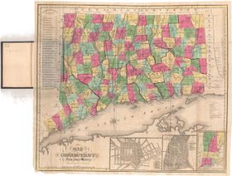
DescriptionMap of Norwich, Connecticut, with the Shetucket River to the east. The boundary of the city is outlined in yellow, with the city center enclosed within a pink boundary line. Physical features include elevation, conveyed with hachure marks; the Yantic River, the Thames River and the Shetucket River; brooks; and swamps. The Norwich and Hartford Turnpike, Norwich and Woodstock Turnpike, Norwich and New London Turnpike, Norwich and Salem Turnpike, and the Norwich City and New London Turnpikes run through the city. The common roads are labeled. The Boston, Norwich and New London Railroad runs along the Thames and Shetucket Rivers. Buildings are depicted as shaded rectangles, with some of them colored green, red, blue, or orange and labeled with letters or numbers. These correspond with buildings on the references list. An inset map in the lower right corner depicts part of Norwich and contains letters and numbers that correspond with the references list in the inset.
Label TextWilliam Lester was a Norwich surveyor who was responsible for several manuscript and printed maps in the Connecticut Historical Society collection in addition to this 1833 folding pocket map of Norwich. Norwich was an active port, with ships traveling frequently back and forth to New York City. Lester's manuscript map probably traveled to New York on one of these ships, since it was engraved and printed there. The printed maps then would have been shipped back to Norwich to be sold by Thomas Robinson, a local Norwich bookseller. Samuel Stiles, whose New York firm engraved and printed the map originally came from East Windsor, Connecticut.
NotesCartographic Note: Scale: 1 inch equals 100 rodsStatus
Not on view