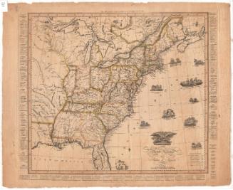
Map of Upper and Lower Canada and United States, contiguous
PrintmakerEngraved by
Thomas Kensett
(American, 1786 - 1829)
PrintmakerEngraved by
Amos Doolittle
(American, 1754 - 1832)
After a work byAfter a work by
Pierre Francois Tardieu
(French, 1757 - 1822)
Date1812
MediumEngraving; black printer's ink on wove paper
DimensionsPrimary Dimensions (image height x width): 13 9/16 x 18 5/16in. (34.4 x 46.5cm)
Sheet (height x width): 15 3/4 x 20 3/8in. (40 x 51.8cm)
ClassificationsGraphics
Credit LineMuseum purchase
Object number1918.5.0
DescriptionMap of what was Upper and Lower Canada, from the wildnerness north of Lower Canada to the north, the border of the United States to the east, the Western Reserve of Connecticut to the south, and Lake Superior to the west. Settlements are shown in districts divided into numbered sections, which correspond to a list of townships that appears below the map. Lakes and rivers are labeled, and width in yards of some of the rivers is provided.
Label TextThe Connecticut Historical Society has three impressions of this map, but they all vary slightly. This version bears the inscription "Engraved by A. Doolittle New Haven / and T. Kensett Cheshire Conn." One of the other copies of the map at the Connecticut Historical Society also bears Doolittle's name. The other does not. The copies also vary in the way the Great Lakes are shaded. These variant versions are known as different "states" and they tell us something about the printing history of the map. This impression appears to correspond to the second state, intermediate between the other two.
NotesCartographic Note: No scaleStatus
Not on view