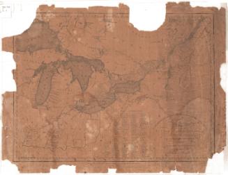
Map of Upper and Lower Canada and United States, contiguous
PrintmakerEngraved by
Thomas Kensett
(American, 1786 - 1829)
PrintmakerEngraved by
Amos Doolittle
(American, 1754 - 1832)
Date1812
MediumEngraving; printer's ink on wove paper
DimensionsPrimary Dimensions (image height x width): 13 1/2 x 18 7/16in. (34.3 x 46.8cm)
Sheet (height x width): 16 1/16 x 20 1/16in. (40.8 x 51cm)
ClassificationsGraphics
Credit LineMuseum purchase
Object number1979.102.0
DescriptionMap of what was Upper and Lower Canada, from the wildnerness north of Lower Canada to the north, the border of the United States to the east, the Western Reserve of Connecticut to the south, and Lake Superior to the west. Settlements are shown in districts divided into numbered sections, which correspond to a list of townships that appears below the map. Lakes and rivers are labeled, and width in yards of some of the rivers is provided.
Label TextThe Connecticut Historical Society has three copies of this Map of Upper and Lower Canada and each copy differs from the other in some small way. This copy has an inscription stating that it was "Engraved by A. Doolittle New Haven and T. Kensett" Cheshire Conn." indicating that Amos Doolittle, as well as Thomas Kensett, had a hand in its creation. In addition, Kensett's name in the cartouche, was engraved in imitation of a signature, unlike the other two copies. All of these changes were made in the original copper plate, producing different versions or "states" of the map.
NotesCartographic Note: No scaleStatus
Not on view