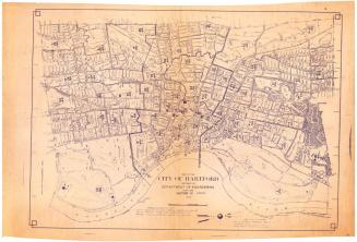
Map of Newington, Connecticut
DraftsmanDrawn by
P. N. Agogliati
(American, born 1921)
MakerUnder the supervision of
Edward C. Fresen
(American, 1907 - 1970)
DraftsmanDrawn by
Morris Knowles, Inc.
(American, 1916 - 1985)
After a work byAfter a work by
Arthur W. Bacon
(American, 1881 - 1970)
Date1949
MediumLithography; printer's ink on wove paper
DimensionsPrimary Dimensions (image height x width): 13 1/8 x 21in. (33.3 x 53.3cm)
Sheet (height x width): 15 x 22in. (38.1 x 55.9cm)
ClassificationsGraphics
Credit LineConnecticut Museum of Culture and History collection
Object number2007.85.0
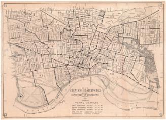
DescriptionMap of Newington, Connecticut, with New Britain and Farmington to the north, West Hartford and Hartford to the east, Wethersfield and Rocky Hill to the south, and Berlin to the west. Streams, streets, schools, hospitals, parks, town property, and the New York, New Haven and Hartford Railroad are shown. A street index is at the right.
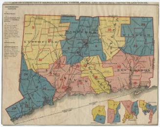
On verso, zone map of same area shows the following Use Districts: A Residence Districts, B Residence Districts, Business Districts, Industrial Districts. Roman numerals I-IV indicate Area Districts.
On verso, zone map of same area shows the following Use Districts: A Residence Districts, B Residence Districts, Business Districts, Industrial Districts. Roman numerals I-IV indicate Area Districts.
Label TextTwo different maps of Newington, Connecticut are printed on the two sides of this single sheet. On one side is a straightforward street map of the town, which was originally created in 1942 and subsequently updated; on the other side is a zoning map, which was originally created in 1930, and likewise updated to reflect subsequent changes. While the street map is a strictly local product, based on Metropolitan District maps and drawn by a local engineer, the zoning map was compiled by a Pittsburgh, Pennsylvania engineering firm. It is interesting to speculate why a Pittsburgh firm might have been hired to create a map of Newington in 1930 instead of a more local entity.
NotesCartographic Note: One inch equals 500 feetStatus
Not on view
Kellogg & Bulkeley
1910-1915
Kellogg & Bulkeley
1915-1920