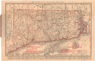
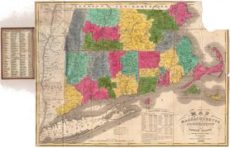
Connecticut Railroads
After a work byAfter a work by
Rand, McNally & Co.
(American, founded 1868)
Datebefore 1986
MediumPhoto-engraving and letterpress; black and red printer's inks on wove paper
DimensionsPrimary Dimensions (image height x width): 11 1/2 x 15 1/2in. (29.2 x 39.4cm)
Sheet (height x width): 18 1/4 x 19 1/2in. (46.4 x 49.5cm)
ClassificationsGraphics
Credit LineConnecticut Museum of Culture and History collection
Object number2012.312.277
DescriptionMap of Connecticut with Massachusetts to the north, Rhode Island to the east, Long Island Sound and part of Long Island to the south, and New York to the west. Railroad are shown as bold red lines superimposed over a nineteenth century map. Names of the railroads are inscribed in red.
Label TextWhen Gregg Turner and Melancthon Jacobus published their study of Connecticut railroads in 1986, they included many maps, most of them adapted from historic maps, but often enhanced to emphasize the railroad lines. This map of Connecticut's railroads in 1878 closely resembles the endpapers of that book, with the railroads, shown as bold red lines, superimposed upon a map of the state. It seems very likely that this map, which is clearly a modern adaptation of an early map, was made in conjunction with the book and perhaps issued separately in a small edition. It is a good example of the adaptive re-use of an historic map by modern scholars for illustrative purposes.
NotesCartographic Note: 1 3/16 inches equals approximately 10 miles. It seems likely that the map is not reproduced at its orignal scale.Date Note: This map resembles maps in Gregg M. Turner and Melancthon W. Jacobus, Connecticut Railroads.... An Illustrated History (Connecticut Historical Society, 1986) and may have been produced in conjunction with that publication.
Status
Not on view