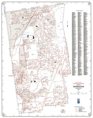
Map of Newington, Connecticut
DraftsmanDrawn by
P. N. Agogliati
(American, born 1921)
MakerUnder the supervision of
Edward C. Fresen
(American, 1907 - 1970)
After a work byAfter a work by
Metropolitan District Commission
(American, founded 1929)
Date1961
MediumLithography; black printer's ink on wove paper with notes in pink pencil and graphite
DimensionsPrimary Dimensions (image height x width): 18 x 28in. (45.7 x 71.1cm)
Sheet (height x width): 19 x 35 1/2in. (48.3 x 90.2cm)
ClassificationsGraphics
Credit LineConnecticut Museum of Culture and History collection
Object number2012.312.276
DescriptionMap of Newington, Connecticut, with New Britain and Farmington to the north, West Hartford and Hartford to the east, Wethersfield and Rocky Hill to the south, and Berlin to the west. Streams, streets, schools, hospitals, parks, town property, and the New York, New Haven and Hartford Railroad are shown. A street index is at the right. Notes in pink pencil include x's on Vivian Street and Summit Street and a line, partially broken, from lower left to upper center. Cedarcrest Hospital and the Newington Hospital for Crippled Children are circled in graphite.
Label TextA map by the Metropolitan District Commission served as the basis for this map of Newington, originally prepared by a local land surveyor in 1942 and updated almost annually thereafter. The latest date that appears on the map is January 17, 1961. Someone used this copy of the map for some purpose, making notes on it in graphite and pink pencil. It is interesting to speculate on the signficance of the pink line that is deliberately inscribed across the western part of town, apparently indicating either a possible route or a boundary.
NotesCartographic Note: One inch equals 500 feetStatus
Not on view