Carte de la partie septentrionale des Etats Unis
PrintmakerEngraved by
Pierre Francois Tardieu
(French, 1757 - 1822)
Datelate 18th century
MediumEngraving; black printer's ink and wataercolor on laid paper
DimensionsPrimary Dimensions (image height x width): 12 3/4 x 16 3/4in. (32.4 x 42.5cm)
Platemark (height x width): 13 1/4 x 17 5/16in. (33.7 x 44cm)
Sheet (height x width): 17 3/4 x 22 3/4in. (45.1 x 57.8cm)
ClassificationsGraphics
Credit LineConnecticut Museum of Culture and History collection
Object number2012.312.274
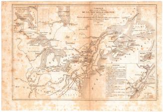
DescriptionMap of portions of Canada and the northern United States extending from Philadelphia up the coast to the Gulf of Saint Lawrence and Newfoundland. George's Bank and other fishing grounds are shown. To the west, the map extends to Lake Ontario. Counties, cities, towns, villages, forts, roads, rivers, lakes, and mountains are shown. States are outlined in green. A table of distances from France and England is at upper left.
Label TextThis French map showing eastern Canada and the northeastern United States appears to have been made sometime before 1791, although this particular copy may well have been printed somewhat later. Vermont, shown here as an independent republic, joined the United States in 1791, becoming the fourteenth state and the first to join after the original thirteen. Also in 1791, Canada was divided into Upper and Lower Canada and remained so divided until 1841. Although France had relinquished its claims to Canada at the end of the French and Indian Wars, France and England remained rivals and French interest in the area remained strong.
NotesCartographic Note: No scaleStatus
Not on view