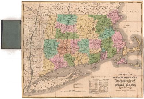
The States of Massachusetts, Connecticut and Rhode Island From the best Authorities
PublisherPublished by
Andrus & Judd
(American, 1832 - 1836)
Date1834
MediumEngraving; black printer's ink and watercolor on wove paper, in cardboard covers
DimensionsPrimary Dimensions (image height x width): 16 3/8 x 20 3/8in. (41.6 x 51.8cm)
Sheet (height x width): 16 3/4 x 20 1/2in. (42.5 x 52.1cm)
ClassificationsGraphics
Credit LineMuseum purchase
Object number1963.100.1
DescriptionPocket map of Massachusetts, Connecticut and Rhode Island, with parts of Vermont and New Hampshire to the north, the Atlantic Ocean to the east, Long Island and the Long Island Sound to the south, and part of New York to the west. The states are divided into counties, colored blue, green, pink, orange or yellow. The map primarily shows methods of transportion: main and common roads, existing and proposed canals, and existing and proposed railroads. The canals depicted are the Farmington in Hartford County, Connecticut, the Blackstone in Worcester County, Massachusetts, and Middlesex in Middlesex County, Massachusetts. The only railroad line shown is a proposed railroad from Albany, New York, to Boston, Massachusetts. Physical features depicted include elevation, conveyed with hachure marks; rivers; and lakes. At the bottom is a statistical table of the populations of Massachusetts, Connecticut and Rhode Island in 1820 and 1830, broken down by counties.
Label TextIt sometimes seems that everyone in Hartford was in the publishing business in the 1830s. A surprising number of Hartford firms published maps during this decade. Andrus & Judd, who published this map of Massachusetts, Connecticut, and Rhode Island, were primarily bookbinders. This speciality may be reflected in the gold-tooled binding of this attractive little map. An earlier edition of the map was published in 1833.
NotesCartographic Note: Scale: 7/8 inch equals about 10 milesStatus
Not on view


H. F. Sumner & Co.
1833

