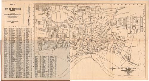
Map of City of Hartford
PublisherPublished by the
Connecticut Valley Guide Co.
(American)
Date1927
MediumLithography; black printer's ink on wove paper, in paper folder
DimensionsPrimary Dimensions (image height x width): 12 7/8 x 19 1/8in. (32.7 x 48.6cm)
Sheet (height x width): 13 3/4 x 25in. (34.9 x 63.5cm)
Sheet (height x width): 13 3/4 x 25in. (34.9 x 63.5cm)
ClassificationsGraphics
Credit LineGift of the estate of Henry A. Castle
DescriptionPocket map of the city of Hartford, Connecticut, oriented east-west on the sheet so that the Connecticut River appears at the bottom. The streets are labeled, as are parks. The New York, New Haven and Hartford Railroad runs through town. Street railways are shown on Maple Avenue, New Britain Avenue, Broad Street, Zion Street, Wethersfield Avenue/Main Street, Windsor Avenue, Albany Avenue, Farmington Avenue, Capitol Avenue, Fairfield Avenue, Washington Street, Blue Hills Avenue, and Asylum Avenue. On the left is a street index.
Object number1962.106.1
NotesCartographic Note: Scale: 2 inches equal 1 mileOn View
Not on view