Colton's Tourist Guide Map of Massachusetts, Rhode Island and Connecticut, with Parts of Maine, New Hampshire, Vermont and New York
PublisherPublished by
G.W. & C.B. Colton & Co.
(American, founded 1865)
PublisherCopyrighted by
Joseph Hutchins Colton
(American, 1800 - 1893)
PrinterPrinted by
Lang & Laing
(American)
Date1866
MediumLithography; black printer's ink and watercolor on wove paper, in cardboard covers
DimensionsPrimary Dimensions (image height x width): 29 1/2 x 30 3/4in. (74.9 x 78.1cm)
Sheet (height x width): 31 x 32 1/8in. (78.7 x 81.6cm)
Sheet (height x width): 31 x 32 1/8in. (78.7 x 81.6cm)
ClassificationsGraphics
Credit LineMuseum purchase
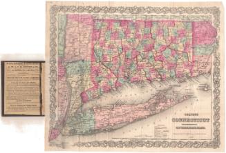
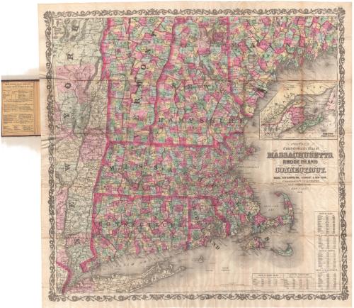
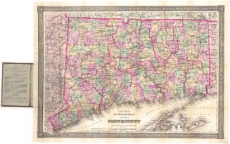
DescriptionPocket map of the northeastern United States, from the northern parts of Vermont and New Hampshire and western Maine to the north, the Atlantic Ocean to the east, Long Island to the south, and the eastern part of New York to the west. The states are outlined in thick pink lines and are divided into counties, also outlined in pink. They are further divided into towns, colored pink, green, blue, or yellow. The railroad lines depicted include New York and New Haven; Danbury and Norwalk; Housatonic; Naugatuck; New York and Boston Air Line; New Haven, Hartford and Springfield; New London, Willimantic and Palmer; Stonington; Norwich and WorcesterConnecticut; and Hartford, Providence and Fishkill. Roads are also shown. Physical features include elevation, conveyed through hachure marks; rivers; and lakes. In the top right is an inset map of Canada East, New Brunswick and Nova Scotia. In the bottom right corner are statistical tables for the populations of Rhode Island, Connecticut, Maine, New Hampshire, Vermont and Massachusetts for 1850 and 1860.
Object number1961.107.1
NotesCartographic Note: Scale: 1 inch equals about 8 milesOn View
Not on view


Matthews-Northrup Company
1913