A Celestial Planisphere, or, Map of the Heavens
PrintmakerEngraved by
Vistus Balch
(American, 1799 - 1884)
PrintmakerEngraved by
Samuel Stiles
(American, 1796 - 1861)
PublisherPublished by
Silas Andrus
(about 1789 - 1861)
Date1861
MediumEngraving; black printer's ink and watercolor on wove paper mounted on fabric
DimensionsPrimary Dimensions (image height x width): 26 x 47 1/2in. (66 x 120.7cm)
Sheet (height x width): 28 1/2 x 49 3/4in. (72.4 x 126.4cm)
ClassificationsGraphics
Credit LineConnecticut Museum of Culture and History collection
Object number2012.312.271
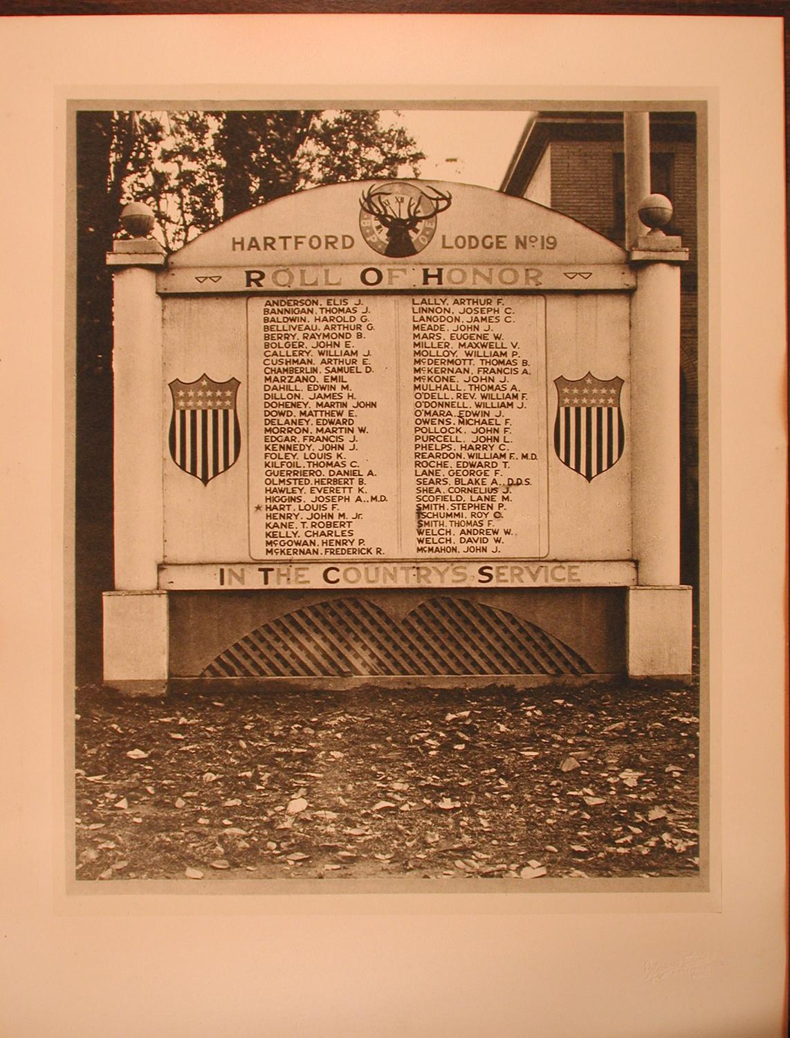
DescriptionCelestial chart showing the northern and southern hemispheres. The twelve months from April to March and the names of the signs of the Zodiac are inscribed on a band linking the two spheres. Constellations are represented figuratively; most are given their English names (the Flying Horse, the Great Bear, the Dragon, the Swan), except in the case of proper names (Andromeda, Cepheus, Perseus, Hercules). Southern constellations include the Air Pump, the Clock, the Furnace, the Microscope, the Painter's Easel, and the Telescope. A key at lower center explains the order of magnitude of the individual stars. Larger stars are identified by name. A second chart at lower center lists those stars visible at Washington, D.C. with the hours of their rising.
Label TextIn 1818, Montgomery R. Bartlett established a school for young ladies in Utica, New York, and in 1825 he published a textbook, Young Ladies' Astronomy, with illustrations engraved by Vistus Balch and Samuel Stiles. This large and impressive Map of the Heavens, which was also engraved by Balch and Stiles, may have been intended to accompany or supplement that text. According to an inscription on it, it was "designed for the use of schools and private families in solving the various problems incident to the study of Astronomy," in other words, as a serious educational tool, despite the fanciful nature of the imagery. Although the copyright notice is dated 1824 and the map is dedicated to John Quincy Adams, who was President of the United States from 1825 to 1829, this copy is apparently a later reprint, published in Hartford, Connecticut by Silus Andrus in 1861.
NotesCartographic Note: No scaleStatus
Not on view