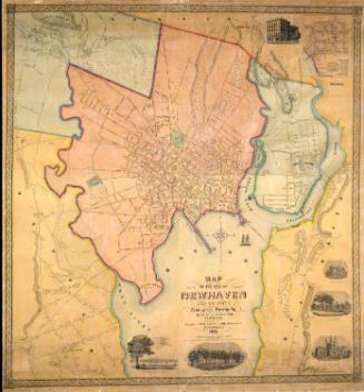
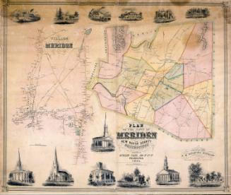
Map of New Haven County
PublisherPublished by
H. & C. T. Smith
(American, active1855 - 1856)
PublisherCopyrighted by
Robert Pearsall Smith
(American, 1827 - 1898)
Date1856
MediumLithography; printer's ink and watercolor on wove paper on fabric
DimensionsPrimary Dimensions (image height x width): 53 1/2 x 53 3/4in. (135.9 x 136.5cm)
Sheet (height x width): 58 3/8 x 55 1/2in. (148.3 x 141cm)
ClassificationsGraphics
Credit LineMuseum purchase
Object number1986.288.1
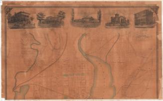
DescriptionMap of New Haven County, Connecticut, with Litchfield County and Hartford County to the north, Middlesex County to the east, Long Island Sound to the south, and Fairfield County to the west. Rivers, ponds, major roads, and railroads are shown. Elevation is indicated by hachure marks. Marshes are indicated by representations of marsh grasses; wooded areas by small trees. Names of property owners are indicated. Locations of court houses, churches, post offices, poor houses, railroad stations, and major businesses are shown. The county map is surrounded by smaller detailed maps of Ansonia, Birmingham, Branford, Cheshire, Derby Narrows, East Haven, Humphreyville (Seymour), Madison, Mayville, Meriden, Milford, Mount Carmel, Naugatuck, New Haven, Wallingford, Waterbury, Waterville, and Westville. Vignettes at left and right overlap the decorative borders to create a trompe-l'oeil effect. Vignettes include Rev. C. W. Everest's Rectory School in Hamden; Residence of Mrs. Whitlock, Southbury; High School, Waterbury; Yale College; Yale College Library; Public Square, New Haven; New York and New Haven Railroad Station; New Haven; Guilford Academy; State Reform School, West Meriden; Town Hall, Meriden; and Residence of John G. North, Oakhill, New Haven. A business directory for New Haven is at upper left. A business directory for Waterbury is at upper right. A table of distances is at upper center. Population statistics are at lower center and agricultural statistics are at lower right.
Label TextThe 1850s was the decade of the great county maps, primarily produced in Philadelphia. Philadelphia lithographers appear to have revelled in their ability to produce very large maps; this 1856 Map of New Haven County was printed on six separate sheets of paper which were then joined on a cloth backing to create a single mammoth map. The large size of such maps allowed the mapmakers to include an amazing amount of detail, ranging from the nature of the topography to the names of the property owners. This makes these county maps incredibly useful resources, though their large size makes them somewhat difficult to use. Orignally most were mounted on rollers and hung on the walls of local businesses, town halls, and county courthouses.
NotesCartographic Note: No scaleStatus
Not on view