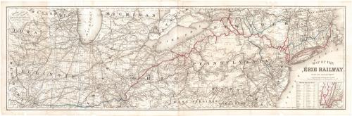
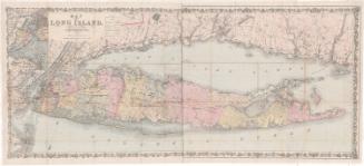
Map of the Erie Railway with its Connections
PrintmakerEngraved by
G.W. & C.B. Colton & Co.
(American, founded 1865)
PrinterPrinted by
G.W. & C.B. Colton & Co.
(American, founded 1865)
PublisherPublished by
G.W. & C.B. Colton & Co.
(American, founded 1865)
Date1869
MediumLithography; black printer's ink and red and blue watercolor on wove paper
DimensionsPrimary Dimensions (image height x width): 16 3/4 x 54 1/2in. (42.5 x 138.4cm)
Sheet (height x width): 18 1/2 x 56 1/4in. (47 x 142.9cm)
ClassificationsGraphics
Credit LineGift of Mrs. David Ramsey
Object number1979.101.1
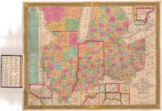
DescriptionMap of the northeastern United States from eastern Iowa and Missouri to the west to the Atlantic Ocean to the east. Wisconsin, Michigan, New York, Vermont, and New Hampshire are to the north, with part of the province of Ontario. Illinois, Indiana, Ohio, and north West Virginia, Virginia, and Delaware are to the south. The Erie Railroad and its connections are shown in red an blue. Other railroad lines are shown in black. A small inset map at lower right shows the railroad lines in the immediate vicinity of New York City. A chart of distances from New York to various cities is also at lower right.
Label TextThis map of the Erie Railway was published in 1869, the year that the first transcontinental railroad was completed. The Erie Railway's connections are shown extending as far west as Saint Louis, and as far east as Boston. The primary connection between New York and Boston is via the Fall River Steamship Line, bypassing Connecticut completely. A secondary rail connection is shown via the Hartford, Providence, and Fishkill Railroad. The Fall River Line, which operated from 1847 to 1937, provided stiff competition for Connecticut railroads and for many years was the preferred means of travel between New York and Boston. In 1893, the Fall River Line would become a subsidiary of the New York, New Haven, and Hartford Railroad.
NotesCartographic Note: One inch equals twenty milesStatus
Not on view


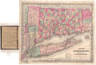
Samuel Augustus Mitchell
1834
Samuel Augustus Mitchell
1835