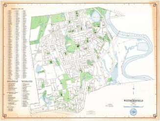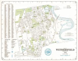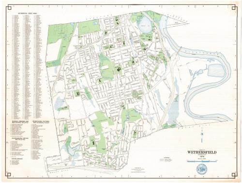
Town of Wethersfield, Connecticut
MakerPrepared by the
Metropolitan District Commission
(American, founded 1929)
Date1976
MediumLithography; colored printer's inks on wove paper
DimensionsPrimary Dimensions (image height x width): 24 x 32in. (61 x 81.3cm)
Sheet (height x width): 25 x 33in. (63.5 x 83.8cm)
ClassificationsGraphics
Credit LineConnecticut Museum of Culture and History collection
Object number1988.228.0
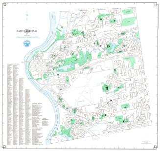
DescriptionMap of the town of Wethersfield, Connecticut, from Hartford to the north, the Connecticut River and Wethersfield Cove and another unnamed cove to the east, Rocky Hill to the south, and Newington to the west. Local roads, including the Berlin Turnpike and Wilbur Cross Parkway are depicted and labeled. Interstate 91 and proposed Interstate 291 with their exit and entrance ramps are also shown. Green is used to denote cemeteries, parks, schools, counry clubs and "open spaces," while blue represents water in the forms of ponds, reservoirs and the river. The Penn Central Railroad runs north-south through the town. The town seal is shown at the bottom, and to the left of the map are lists of streets; recreational, cultural and historical places; schools, libraries and educational facilities; government offices and facilities; and miscellaneous.
Label TextWethersfield was one of the original towns to join in the formation of the Metropolitan District in 1929. It was then a small farming community and the site of the Connecticut State Prison. By the 1970s, the prison was gone and its site overlooking Wethersfield Cove was occupied by the Folly Brook Natural Area. Interstate 91 carried travelers zooming past Wethersfield's historic center and quiet tree-lined streets. A second interstate highway, I-291 also appears in this 1976 map, but this segment of the proposed beltway around Hartford was never built.
NotesCartographic Note: One inch equals 1000 feetStatus
Not on view