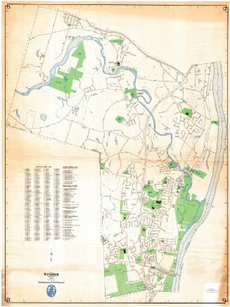
Town of Windsor, Connecticut
MakerPrepared by the
Metropolitan District Commission
(American, founded 1929)
Date1976
MediumLithography; colored printer's inks on wove paper
DimensionsPrimary Dimensions (image height x width): 23 7/8 x 17 1/2in. (60.6 x 44.5cm)
Sheet (height x width): 24 1/8 x 18in. (61.3 x 45.7cm)
ClassificationsGraphics
Credit LineConnecticut Museum of Culture and History collection
Object number1988.227.0
DescriptionMap of the town of Windsor, Connecticut with East Granby and Windsor Locks to the north, the Connecticut River to the east, Hartford to the south, and Bloomfield and East Granbuy to the west. Highways and local roads are shown and named. Cemeteries, historic sites, parks, and schools are shown. Open space is green. The Connecticut River, the Farmington River, and other streams and ponds are blue. The MDC Poquonock Water Pollution Control Plant and the Town of Windsor Sanitary Landfill are both shown. A street index and a key to educational facilities; recreational, cultural, and historic places; and government offices is at lower left. A compass is at upper right.
Label TextWindsor was one of the original towns that joined the Metropolitan District Commission. The MDC was formed in 1929 to address the needs of Hartford and its immediate suburbs with respect to water supply and sewage disposal. Windsor at the time had no sewage treatment plant; its sewers still drained directly into the Farmington River and the Connecticut River. Early plans called for all of the area sewage to be treated in one central plant in Hartford, but additional sewage treatment plants were soon required as the pollution of the Connecticut River began to be perceived as a major problem. The Poquonock Water Pollution Control Plant in Windsor was completed in the early 1960s, roughly ten years before this map was made.
The Metroplitan District Commission issued its maps in different sizes. This is an example of one of the smaller maps.
NotesCartographic Note: One half inch equals 1000 feetThe Metroplitan District Commission issued its maps in different sizes. This is an example of one of the smaller maps.
Status
Not on view