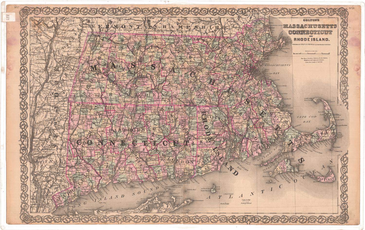
Colton's Connecticut with portions of New York and Rhode Island
PublisherPublished by
G.W. & C.B. Colton & Co.
(American, founded 1865)
PublisherCopyrighted by
J. H. Colton & Co.
(American, founded 1831)
Date1867
MediumLithography; black printer's ink and watercolor on wove paper, in cardboard covers
DimensionsPrimary Dimensions (image height x width): 12 5/8 x 15in. (32.1 x 38.1cm)
Sheet (height x width): 13 3/8 x 15 3/4in. (34 x 40cm)
ClassificationsGraphics
Credit LineMuseum purchase
Object number1960.144.0
DescriptionMap of the state of Connecticut, with part of Massachusetts to the north, part of Rhode Island to the east, Long Island and the Long Island Sound to the south, and part of New York to the west. The state is divided into counties, outlined in red, and towns, colored pink, green, or yellow. Railroads are depicted on the map, include the New York and New Haven; Danbury and Norwalk; Naugatuck; Housatonic; Hartford, Providence and Fishkill; New Haven and New London; Norwich and Worcester; Stonington and Providence; and New York and Boston Air Line. Physical features include elevation, conveyed with hachure marks; rivers; and lakes/ponds. On the inside of the front cover is an advertisement for maps and atlases sold by G.W. & C.B. Colton & Co.
Label TextThis map of Connecticut first appeared in Colton's Atlas of the World, published in New York by J. H. Colton & Co. in 1855. Over the next twenty years, the same map was repeatedly reissued by Colton and his sons. Though it was occasionally updated as new towns were added and other changes took place, the individual editions were often rather badly out-of-date. This 1867 edition appears to be virtually identical with the 1869 edition which was published two years later. Neither includes the towns of Sprague, incorporated in 1861, or Middlefield, incorporated in 1866. In both cases, the last new town to appear is Morris, which was incorporated in 1859.
NotesCartographic Note: Scale: 1 inch equals 10 milesStatus
Not on view