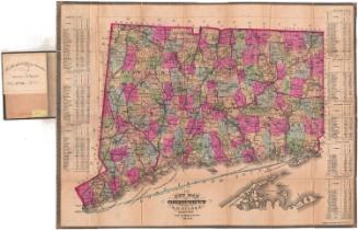
New Map of Connecticut
PublisherPublished by
Samuel D. Tilden
(American, 1828 - 1893)
PrintmakerLithographed by
Bingham & Dodd
(1860 - 1878)
Date1876
MediumLithography; black printer's ink and watercolor on laid paper, lined with paper, in cardboard covers
DimensionsPrimary Dimensions (image height x width): 20 3/4 x 27in. (52.7 x 68.6cm)
Sheet (height x width): 21 5/8 x 27 3/4in. (54.9 x 70.5cm)
Mount (height x width): 21 5/8 x 27 3/4in. (54.9 x 70.5cm)
ClassificationsGraphics
Credit LineGift of Edmund Arnold Merriam and Mrs. John Zellers
Object number1960.142.1
DescriptionPocket map of the state of Connecticut, with the border of Massachusetts to the north, the border of Rhode Island to the east, part of Long Island and the Long Island Sound to the south, and the border of New York to the west. The state is divided into counties, outlined in red, and towns, colored blue, green, yellow, pink or peach. Roads and railroad lines are shown. The railroad lines depicted include New York, New Haven and Hartford; Housatonic; Danbury and Norwalk; Shepaug; New Haven and Northampton; New Haven, Middletown and Willimantic; Hartford, Providence and Fishkill; Hartford and Erie; New London Northern; and Norwich and Worcester. The population of each county's towns is listed in tables on the left and right sides of the image.
Label TextSamuel D.Tilden is perhaps best known as the partner of Alden Baker in the firm Baker & Tilden, which published an important early atlas of Hartford County in 1869. After the partnership dissolved, Tilden continued in the map publishing business, turning out "new maps" of Connecticut year after year through the 1870s and 1880s. Folding pocket maps like this one were especially popular with business travelers and tourists, because they could easily be carried in ones pocket. Folding and unfolding the maps in order to consult them caused them to wear out and continues to pose a challenge to those consulting them today.
NotesCartographic Note: Scale: 1 inch equals 4 1/2 milesStatus
Not on view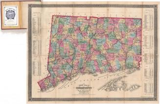


Lucius Stebbins & Co.
1859