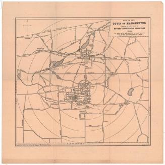
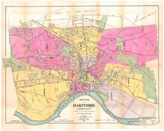
Driving Road Chart of Hartford and Vicinity, 15 Miles around
PrinterPrinted by
Packard, Butler & Partridge
(American, 1883 - 1886)
PublisherPublished by
Albert A. Hyde & Co.
(American, active 1884)
Date1884
MediumLithography; black and pink printer's inks and watercolor on laid paper, lined with linen, in cardboard covers
DimensionsPrimary Dimensions (image height x width): 41 1/4 x 40 1/4in. (104.8 x 102.2cm)
Sheet (height x width): 42 3/8 x 41in. (107.6 x 104.1cm)
Mount (height x width): 42 3/8 x 41in. (107.6 x 104.1cm)
ClassificationsGraphics
Credit LineConnecticut Museum of Culture and History collection
Object number1960.141.0
DescriptionMap of Hartford, Connecticut and the surrounding area, from Suffield to the north, the borders of Tolland and Coventry to the east, Middletown to the south, and Bristol and Burlington to the west. Each of the towns depicted is outlined in bright pink, yellow, green, purple or orange. There are concentric circles radiating out from the center of Hartford in 1-mile increments. Roads are shown in red. Landowners names are provided. Physical features depicted include rivers and lakes. The cartouche is decorated with an image of a man and woman in a horse-drawn carriage.
Label TextThere were no automobiles in 1884. The drivers on the roads in the fifteen-mile radius around Hartford shown on this map would have been driving horses and carriages, presumably for recreation. Coaching and driving were popular during the 1880s, especially among the wealthy elite, and the area about Hartford offered many opportunities for pleasant scenic country drives.
NotesCartographic Note: Scale: About 1 inch equals 3/4 mileDate Note: The date was taken from the record in the Library of Congress for another copy of the same map.
Status
Not on view