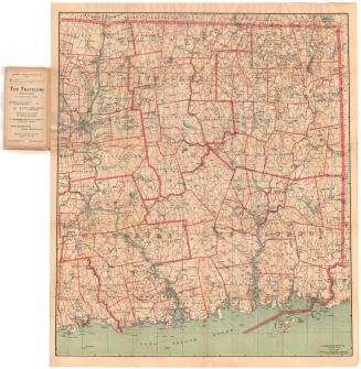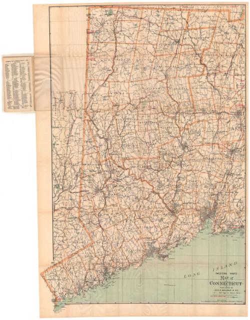
Map of Connecticut, Western Part
PrinterPrinted by
Geo. H. Walker & Co.
(American, founded 1880)
Date1905
MediumLithography; black and colored printer's inks on wove paper, in paper covers
DimensionsPrimary Dimensions (image height x width): 40 1/4 x 25 1/4in. (102.2 x 64.1cm)
Sheet (height x width): 41 3/8 x 27 5/8in. (105.1 x 70.2cm)
ClassificationsGraphics
Credit LineMuseum purchase
Object number1956.94.1
DescriptionPocket map of the western part of Connecticut, with no borders shown to the north and east, the Long Island Sound to the south, and part of New York to the west. Town divisions are marked with broken solid lines and a brownish-yellow line. Road routes between points within Connecticut and to points in Massachusetts and New York are shown in red.Physical features depicted include rivers and lakes. Also within the paper covers is an index to the names (of towns, hills, etc.) that appear on the map, and population information by county and town.
Label TextIn 1900, the Pope Manufacturing Company in Hartford, Connecticut was America's biggest producer of automobiles. Pope also manufactured bicycles and this 1905 map appears to target both bicyclists and early motorists, showing the "best routes" for travel through western Connecticut. By focussing on just part of the state, publisher George H. Walker & Co.was able to show the area at a larger scale and thus to provide more detail. Before the existence of a consistent, numbered highway system, finding ones way around Connecticut was a considerable challenge and this highly legible map must have been a useful tool for travelers.
NotesCartographic Note: Scale: 1 inch equals almost 2 milesStatus
Not on view