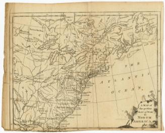
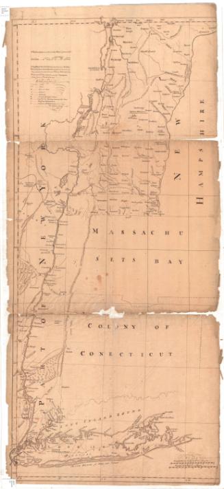
A Map of the Most Inhabited Part of New England
DraftsmanDrawn by
Braddock Mead
(Irish, 1685 - 1757)
PublisherPublished by
Thomas Jefferys
(English, 1710 - 1771)
Date1774
MediumEngraving; black printer's ink on laid paper, lined with linen, in leather container
DimensionsPrimary Dimensions (image height x width): 41 1/8 x 39 3/8in. (104.5 x 100cm)
Sheet (height x width): 41 1/4 x 39 3/8in. (104.8 x 100cm)
Mount (height x width): 41 1/4 x 39 3/8in. (104.8 x 100cm)
Sheet (height x width): 41 1/4 x 39 3/8in. (104.8 x 100cm)
Mount (height x width): 41 1/4 x 39 3/8in. (104.8 x 100cm)
ClassificationsGraphics
Credit LineConnecticut Museum of Culture and History collection
DescriptionMap of New England, depicting the provinces of New Hampshire and Massachusetts Bay, and the colonies of Connecticut and Rhode Island. To the east is the Atlantic Ocean, to the south is Long Island and the Long Island Sound, and to the west is part of the state of New York. The provinces and colonies are divided into counties and towns, both of which are labeled. Forts, meeting houses, and English and Indian habitations are represented by symbols listed in the Explanation. Physical features depicted include elevation, represented with clusters of peaks; rivers; ponds; lakes; and islands. In the Explanation list are letters explaining the abbreviations for some of the natural features (C or Cr for creek, for example). In the top left corner is an inset map of Boston and at the bottom is an inset chart of Boston Harbor with water depth. The cartouche is decorated with a scene depicting Pilgrims arriving at Plymouth, being greeted by a Native American and an allegorical figure holding a liberty cap.
Object number1956.93.1
NotesCartographic Note: Scale: 20 English marine leagues to 1 degree; 69 1/2 miles to 1 degreeOn View
Not on view