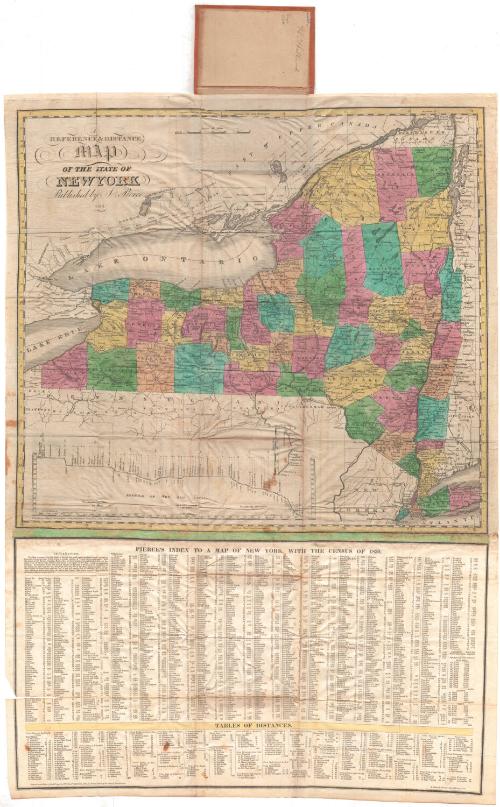
A Reference & Distance Map of the State of New York
PrinterPrinted by
Sidney Babcock
(American, 1797 - 1888)
PublisherPublished by
Justin Pierce
(American, 1805 - 1879)
Date1831
MediumEngraving; black printer's ink and watercolor on wove paper, in cardboard covers
Lithography; black printer's ink and watercolor on wove paper, in cardboard covers
DimensionsPrimary Dimensions (image height x width): 18 1/4 x 20in. (46.4 x 50.8cm)
Platemark (width only): 20 7/8in. (53cm)
Sheet (height x width): 29 1/2 x 21in. (74.9 x 53.3cm)
Platemark (width only): 20 7/8in. (53cm)
Sheet (height x width): 29 1/2 x 21in. (74.9 x 53.3cm)
ClassificationsGraphics
Credit LineMuseum purchase
DescriptionMap of the state of New York, with parts of Upper and Lower Canada to the north; parts of Vermont, Massachusetts and Connecticut to the east; parts of Pennsylvania and New Jersey to the south; and Lake Erie and part of Canada to the west. The state is divided into counties, which are colored green, blue, pink, yellow or peach. The Erie Canal is shown on the map, and a profile of it appears to the bottom left. Physical features depicted include lakes and rivers. Pasted to the bottom of the map is another sheet of paper with population information for all of the towns in New York and distance information below.
Object number1959.115.1
NotesCartographic Note: Scale: 1 inch equals about 19 milesOn View
Not on view
Samuel Augustus Mitchell
1835
Samuel Augustus Mitchell
1834