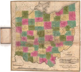
Map of the State of Ohio from the latest and best Authorities; Including the census of 1830
PrintmakerEngraved by
Abner Reed
(American, 1771 - 1866)
PublisherPublished by
Silas Andrus
(about 1789 - 1861)
Date1835
MediumEngraving; black printer's ink and watercolor on wove paper, in cardboard covers
DimensionsPrimary Dimensions (image height x width): 18 7/8 x 15 3/4in. (47.9 x 40cm)
Sheet (height x width): 19 x 16in. (48.3 x 40.6cm)
ClassificationsGraphics
Credit LineMuseum purchase
Object number1953.74.0
DescriptionMap of the state of Ohio, with part of Michigan, Canada and Lake Erie to the north; part of Pennsylvania to the east; part of Kentucky and Virginia to the south; and part of Indiana to the west. The state is divided into townships, colored green, yellow, blue or pink. The Ohio and Erie Canal is colored red and the unnamed Miami and Erie Canal is colored blue, with a red line running between Dayton and Cincinnati. Physical features depicted include elevation, conveyed with hachure marks; rivers; lakes; and marshes. In the bottom left corner is population information for the state between 1791 and 1830.
Label TextAbner Reed was truly a jack of all trades. In addition to engraving maps and prints, he painted signs, grained chairs, and decorated drums and carriages. He was also an author and school teacher. A number of his apprentices went on to become sucessful engravers in their own right. This Map of the State of Ohio "from the latest and best authorities" is actually a reprint of a plate that Reed originally engraved and published in 1820. The Connecticut Historical Society also has an 1831 edition of this same map. The ongoing production of maps of Ohio by Hartford publishers is indicative of ongoing interest in Connecticut in its former Western Reserve.
NotesCartographic Note: Scale: 1 inch equals 15 milesStatus
Not on view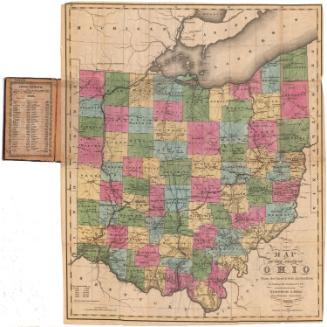
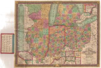
Samuel Augustus Mitchell
1834

Samuel Augustus Mitchell
1835