Map of the United States Constructed from the Latest Authorities
PublisherPublished by
C. S. Williams
(American, active 1834 - 1846)
Date1833
MediumEngraving; black printer's ink and watercolor on wove paper on paper, in cardboard covers
DimensionsPrimary Dimensions (image height x width): 16 5/8 x 21 1/2in. (42.2 x 54.6cm)
Sheet (height x width): 16 5/8 x 21 5/8in. (42.2 x 54.9cm)
Mount (height x width): 16 5/8 x 21 5/8in. (42.2 x 54.9cm)
ClassificationsGraphics
Credit LineMuseum purchase
Object number1952.100.0
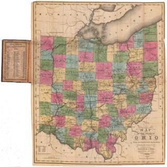
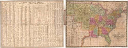
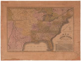
DescriptionPocket map of the United States, with part of Upper and Lower Canada to the north, the Atlantic Ocean to the east, the Gulf of Mexico to the south, and Mexico and Missouri Territory to the west. The states are colored pink, green, blue, yellow and peach. Physical features depicted included elevation, conveyed with clusters of peaks, rivers, and lakes. In the bottom left is a statistical table containing the populations of the states and their capitals in 1830. Also folded into the covers is the Traveler's Directory, which contains information about steam boat and canal routes, principal roads, and population information about the states and their towns.
Label TextIn 1834, C. S. Williams was in New Haven, Connecticut, where he published a Travelers Directory and Statistical View of the United States. This map may have been intended to accompany that publication. Though the map printing and publishing industry was still widely dispersed in the 1830s, with printers and publishers active in many small cities like New Haven and Hartford, by the 1840s, the business was becoming increasingly centered in Philadelphia. By 1841, C. S. Williams was established there, continuing to pursue his career as a map publisher.
NotesCartographic Note: Scale: 1 inch equals 110 milesStatus
Not on view


H. F. Sumner & Co.
1833