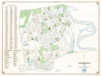
Town of Rocky Hill, Connecticut
MakerPrepared by the
Metropolitan District Commission
(American, founded 1929)
Date1977
MediumLithography; colored printer's inks on wove paper
DimensionsPrimary Dimensions (image height x width): 23 5/8 x 31 5/8in. (60 x 80.3cm)
Sheet (height x width): 24 3/4 x 32 3/4in. (62.9 x 83.2cm)
ClassificationsGraphics
Credit LineConnecticut Museum of Culture and History collection
Object number1988.225.0
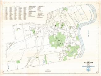
DescriptionMap of the town of Rocky Hill, Connecticut, with Wethersfield to the north, the Connecticut River and Glastonbury to the east, Cromwell to the south, and Berlin and Newington to the west. The Metropolitan District Commission Water Pollution Control Facility is in the northeast part of town. The Vexation Hill Water Storage Tank is in the northwest part of town. Other prominent features include Dinosaur State Park, Rose Hill Memorial Park, the Rocky Hill-Glastonbury Ferry, and the Veterans Hospital. Streets, railroads, streams, and ponds are shown. Interstate 91 and proposed Interstate 491 figure prominently, with a large highway interchange in the northern part of town. A scale of miles and the Rocky Hill seal are at the lower right. A street index and a key to schools, libraries, educational facilities, recreational facilities, cultural and historic sites, and govermment offices and facilities are upper left.
Label TextIn this 1977 map, the northwest corner of the town of Rocky Hill, Connecticut is dominated by a mammoth highway interchange, where Interstate 91 intersects with a second interstate highway, here identified as I-491. This name I-491 is something of a mystery. Though Interstate 491 was a Hartford bypass proposed in the early 1960s, it did not pass through Rocky Hill and it was never built. In the 1970s, Interstate 291, a beltway that would have encircled Hartford to the west, was under construction, and the name I-291 appears on a 1976 Metropolitan District map of Rocky Hill. Is the name I-491 on this map simply a mistake? This segment of I-291 was never built either, to great relief of Rocky Hill residents who opposed its construction.
NotesCartographic Note: One inch equals 1000 feetStatus
Not on view