Pinar del Rio
Original OwnerOriginally owned by
Brigadier General George Malpas Cole
(American, died 1933)
PrintmakerLithographed by
Julius Bien
(1826 - 1909)
Date1898
MediumLithography; black and red printer's inks on cotton
DimensionsPrimary Dimensions (image height x width): 23 7/8 x 38 3/4in. (60.6 x 98.4cm)
Sheet (height x width): 26 3/4 x 41 3/4in. (67.9 x 106cm)
ClassificationsGraphics
Credit LineGift of Miss Clara B. M. Cole
Object number1953.56.27
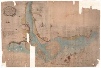
DescriptionMap of the western part of the province of Pinar del Rio. Places are marked with their name and a circular symbol. Roads and what appear to be railroads are shown. Physical features include swamps, rivers and islands. Water depth in fathoms is shown around the coastline. Other numbers are shown around on the map, in the areas representing water. In the top left is an inset index map showing all of the maps in the series.
Label TextAlthough the Connecticut National Guard was used exclusively for coastal defense and saw no action during the Spanish American War, Connecticut men in the regular army saw active service, primarily in the Philippines, but also in Cuba and Puerto Rico. This map belonged to George Malpas Cole of Hartford, Connecticut, who served as Lieutenant-Colonel of the Fourth United States Volunteers in Cuba. A large number of Cuban rebels fighting against the Spanish were concerntrated in the western province of Pinar del Rio.
NotesCartographic Note: Scale: 1:250,000Status
Not on view