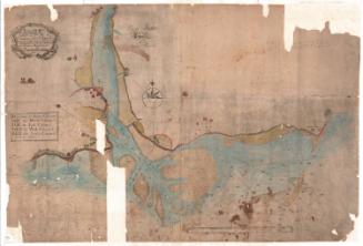
Santiago de Cube Province, Cuba
DraftsmanDrawn by
Charles H. Ourand
(American, 1857 - after 1920)
PrintmakerLithographed by
Julius Bien
(1826 - 1909)
Original OwnerOriginally owned by
George Malpas Cole
(American, 1853 - 1933)
Date1898
MediumLithography; black and red printer's ink on cotton
DimensionsPrimary Dimensions (image height x width): 38 3/4 x 23 1/2in. (98.4 x 59.7cm)
Sheet (height x width): 41 3/4 x 26 3/4in. (106 x 67.9cm)
Sheet (height x width): 41 3/4 x 26 3/4in. (106 x 67.9cm)
ClassificationsGraphics
Credit LineGift of Miss Clara B. M. Cole
DescriptionMap of part of the province of Santiago de Cuba. Places are marked with their name and a circular symbol. Roads and what appear to be railroads are shown. Physical features include islands. Water depth in fathoms is shown around Bahia de Nipe. Other numbers are shown around on the map, in the areas representing water. Some of the numbers have letters representing some kind of units of measurement, although what they are is unclear. In the top left is an inset index map showing all of the maps in the series.
Object number1953.56.24
NotesCartographical Note: Scale: 1:250,000
Medium Note: Most sources state that cloth maps were first used by the American military in World War II, but this map is part of a series of cloth maps of Cuba produced by the Adjutant General's Office for use during the Spanish American War.On View
Not on view