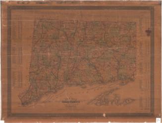
New Map of Connecticut
PublisherPublished by
Samuel D. Tilden
(American, 1828 - 1893)
PrintmakerLithographed by
Bingham & Dodd
(1860 - 1878)
Date1871
MediumLithography; black printer's ink and watercolor on wove paper, lined with linen, in cardboard covers
DimensionsPrimary Dimensions (image height x width): 21 1/4 x 27 7/8in. (54 x 70.8cm)
Sheet (height x width): 22 1/8 x 29 1/8in. (56.2 x 74cm)
Mount (height x width): 22 1/8 x 29 1/8in. (56.2 x 74cm)
ClassificationsGraphics
Credit LineGift of the Colonial Dames
Object number1948.20.1
DescriptionPocket map of Connecticut, with the border of Massachusetts to the north, Rhode Island to the east, part of Long Island and the Long Island sound to the south, and New York to the west. The state is divided into counties, outlined in red, and towns, colored pink, green, blue, yellow and peach. Population centers are marked with clusters of black squares. Roads are shown. Railroad lines depicted include the Portchester and Ridgefield; New York, New Haven and Hartford; Housatonic; Danbury and Norwalk; Saugatuck Valley (projected); Shepaug Valley; Boston, Hartford and Erie; New Haven, Middletown and Willimantic/Air Line; Hartford, Providence and Fishkill; New Haven and Northampton; New London Northern; and Norwich and Worcester. The populations of the towns in each county for 1860 and 1870 is listed in statistical tables around main image.
Label TextThe same map might be issued in different formats to serve different purposes. Hartford map publisher Samuel Tilden's New Map of Connecticut went through several editions, all of them printed by the local lithography firm, Bingham & Dodd. Most of the versions preserved in the Connecticut Historical Society are flat maps that might have been stored in a drawer or in a portfolio or framed and hung on a wall. This copy of Tilden's 1871 map was issued as a folding pocket map. Because they were unfolded and refolded during use, pocket maps tended to wear out much more quickly than other maps, so it is likely that fewer maps in this format survived.
NotesCartographic Note: Scale: 1 inch equals 4 1/2 milesStatus
Not on view


Lucius Stebbins & Co.
1859
